Skip to content
YearMaps
Turkmenistan · Landforms

Mountain Ranges, Deserts and Landforms of Turkmenistan

Asia is the largest of the 6 mountain ranges, deserts and other landforms recorded for Turkmenistan, at 46.28M km², ahead of Turan Lowland at 873,039 km². The full list follows.

How this list is built: Ranked by mapped area. Covers mountain ranges, deserts, plateaus, named glaciers, plains, basins, peninsulas and capes. One that crosses a border is listed under every country it lies in, with the area of the whole feature. It covers the mountain ranges, deserts and other landforms indexed in YearMaps, drawn from open geospatial data, and is not an exhaustive national register.

Landforms Listed
6
Top Ranked
46.28M km²
Asia
Second
873,039 km²
Turan Lowland
Profiled Below
5
Photo, encyclopedia text and figures
Mountain Ranges, Deserts and Landforms of Turkmenistan
#NameArea
1Asia46.28M km²
2Turan Lowland873,039 km²
3Ustyurt Plateau76,986 km²
4Kopet Dag Mountains40,042 km²
5Qizilqum Desert264 km²
6Garagum Desert8 km²

The Landforms of Turkmenistan in Detail

The 5 mountain ranges, deserts and other landforms above that have an encyclopedia article, in the same order, each with its photograph, figures and the places around it.

Turan Lowland
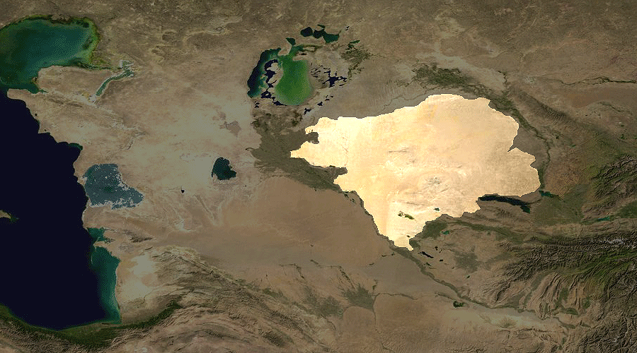
Image via Wikimedia Commons (author and licence on the file page).

Turan Lowland

Plain · 873,039 km²

Turan Lowland is a plain in Asia, covering an estimated 873,039 km². It extends across Turkmenistan, Uzbekistan and Kazakhstan. It is the 19th-largest of the 231 landforms with a mapped extent in YearMaps.

The Turan Depression, Turan Lowland or Turanian Basin is a low-lying desert basin region stretching from southern Turkmenistan through Uzbekistan to Kazakhstan.

Adapted from Wikipedia: Turan Depression (CC BY-SA 4.0).

Feature class
Plain
Mapped extent
873,039 km²
Size rank
#19 of 231 landforms
Region
Asia
Countries
Turkmenistan, Uzbekistan, Kazakhstan
Coordinates
41.7724°, 62.8901°
Summits:
Gora Arlan (1,880 m), Ayrybaba (3,137 m)
Ranges:
Kopet Dag Mountains (Asia), Karatau Range (Asia)
Settlements:
Tejen (205 km), Mary (213 km), Kaka (223 km)

View on the live map

More about Turan Lowland

Geography

The lowland region lies to the east of the Caspian Sea and southeast of the Aral Sea in the vast Aral–Caspian Depression but extends to parts above sea level as well. It is one of the largest expanses of sand in the world, covering an area of around 3 million km2. On average, the region receives less than 15 inches (380 mm) of rainfall per year. The Karakum desert lies at the southern portion of the Turan Lowlands.

The part of the depression adjacent to the Aral Sea is drainless. It includes a network of temporary streams usually ending in sor salt flats, which seasonally become salt lakes.

Three of the largest cities in the Turan Depression are Daşoguz in Turkmenistan, Nukus in Uzbekistan, and Urganch, also in Uzbekistan. Akjagaýa in Turkmenistan is 267 feet (81 meters) below sea level.

Sections adapted from Wikipedia: Turan Depression (CC BY-SA 4.0).

Ustyurt Plateau
Image via Wikimedia Commons (author and licence on the file page).

Ustyurt Plateau

Plateau · 76,986 km²

Ustyurt Plateau is a plateau in Asia, covering an estimated 76,986 km². It extends across Kazakhstan, Uzbekistan and Turkmenistan.

The Ustyurt or Ust-Yurt (from Kazakh: Үстірт; Uzbek: Ustyurt; Turkmen: Üstyurt; Karakalpak: Ústirt — flat hill, plateau) is a transboundary clay desert shared by Kazakhstan, Turkmenistan, and Uzbekistan.

The plateau's semi-nomadic population raises camels, goats, and sheep.

Adapted from Wikipedia: Ustyurt Plateau (CC BY-SA 4.0).

Feature class
Plateau
Mapped extent
76,986 km²
Size rank
#37 of 69 plateaus
Region
Asia
Countries
Kazakhstan, Uzbekistan, Turkmenistan
Coordinates
44.0394°, 55.5062°
Summits:
Gora Arlan (1,880 m), Ayrybaba (3,137 m)
Ranges:
Kopet Dag Mountains (Asia), Lesser Caucasus (Asia)
Settlements:
Koneurgench (353 km), Daşoguz (438 km), Türkmenbaşy (493 km)

View on the live map

More about Ustyurt Plateau

Geography

The Ustyurt is located between the Dead Kultuk, Mangyshlak Peninsula and Kara-Bogaz-Gol of the Caspian Sea to the west, and the Aral Sea, Amudarya Delta and Sarygamysh Lake to the east.

It extends roughly 200,000 km2 (77,000 sq mi), with an average altitude of 150 m (490 ft). Its highest point rises to 370 m (1,200 ft) in the south-west. At its northeastern edge it drops steeply to the Aral Sea and the surrounding plain.

The Ustyurt Plateau is bounded by steep cliffs called chinks nearly from everywhere. To the east, it encompasses the historical western shoreline of the Aral Sea. In the southern region, it extends to the Kunya-Darya alluvial plain and the valley of the Uzboy, while in the west, it reaches the Karynyaryk depression.

Sections adapted from Wikipedia: Ustyurt Plateau (CC BY-SA 4.0).

Ustyurt Plateau: Key Facts

Key facts about Ustyurt Plateau
Area200,000 km²
Elevation365 m

Facts from Wikidata Q913329 (CC0).

Kopet Dag Mountains
Image via Wikimedia Commons (author and licence on the file page).

Kopet Dag Mountains

Range/mtn · 40,042 km²

Kopet Dag Mountains is a range/mtn in Asia, covering an estimated 40,042 km². It extends across Turkmenistan and Iran.

The Köpet Dag (Turkmen: Köpetdag [ˌkœpɛtˈdɑːʁ]; Persian: کپه‌داغ), also known as the Turkmen–Khorasan Mountain Range, is a mountain range on the border between Turkmenistan and Iran that extends about 650 kilometres (400 mi) along the border southeast of the Caspian Sea, stretching northwest-southeast from near the Caspian Sea in the northwest to the Hari River in the southeast. In the southwest it borders on the parallel eastern endings of the Alborz mountains being together part of the much larger Alpide belt. The highest peak of the range in Turkmenistan is the Mount Rizeh (Kuh-e Rizeh), located at the southwest of the capital Ashgabat and stands at 2,940 metres (9,646 ft). The highest Iranian summit is Mount Quchan (Kuh-e Quchan) at 3,191 metres (10,469 ft).

Adapted from Wikipedia: Kopet Dag (CC BY-SA 4.0).

Feature class
Range/mtn
Mapped extent
40,042 km²
Size rank
#92 of 216 mountain ranges
Region
Asia
Countries
Turkmenistan, Iran
Coordinates
38.8772°, 56.1275°
Summits:
Gora Arlan (1,880 m), Ayrybaba (3,137 m)
Adjacent ranges:
Lesser Caucasus (Asia), Karatau Range (Asia)
Settlements:
Buzmeyin (101 km), Ashgabat (119 km), Kaka (245 km)

View on the live map

More about Kopet Dag Mountains

Geology

Geologically, the Kopet Dag Range is made chiefly of Lower Cretaceous sedimentary rocks with a smaller portion of Jurassic rocks in the southeastern parts. The mountains were formed in the Miocene and the Pliocene during the Alpine orogeny. As the Tethys Sea was closed and the Arabian plate collided with the Iranian plate and was pushed against it and with the clockwise movement of the Eurasian plate towards the Iranian plate and their final collision, the Iranian plate was pressed against the Turan Platform. This collision folded the entire rocks that had been deposited in this geosyncline or basin from the Jurassic to the Miocene and formed the Kopet Dag Mountains.

Sections adapted from Wikipedia: Kopet Dag (CC BY-SA 4.0).

Kopet Dag Mountains: Key Facts

Key facts about Kopet Dag Mountains
Length650 km
Area35,000 km²

Facts from Wikidata Q328072 (CC0).

Qizilqum Desert
Image via Wikimedia Commons (author and licence on the file page).

Qizilqum Desert

Desert · 264 km²

Qizilqum Desert is a desert in Asia, covering an estimated 264 km². It extends across Kazakhstan, Turkmenistan and Uzbekistan.

The Kyzylkum Desert (Uzbek: Qizilqum; Kazakh: Qyzylqūm) is the 15th largest desert in the world. Its name means 'Red Sand' in Turkic languages. It is located in Central Asia, in the land between the confluent rivers Amu Darya and Syr Darya, a region historically known as Transoxania. Today it is divided among Kazakhstan, Turkmenistan and Uzbekistan. It covers about 298,000 km2 (115,000 sq mi).

Adapted from Wikipedia: Kyzylkum Desert (CC BY-SA 4.0).

Feature class
Desert
Mapped extent
264 km²
Size rank
#54 of 58 deserts
Region
Asia
Countries
Kazakhstan, Turkmenistan, Uzbekistan
Coordinates
46.8672°, 60.5550°
Summits:
Gora Arlan (1,880 m), Ayrybaba (3,137 m)
Ranges:
Karatau Range (Asia), Kopet Dag Mountains (Asia)
Settlements:
Koneurgench (518 km), Daşoguz (561 km), Türkmenabat (897 km)

View on the live map

More about Qizilqum Desert

Geography

Kyzylkum is mainly located in Uzbekistan. Its territory consists mainly of an extensive plain at an altitude up to 300 m (980 ft) above sea level, with a number of depressions and highlands (Sultanuizdag, Bukantau). Most of the area is covered with dunes (barchans); in the northwest large areas are covered with takirs (clay coatings); there are also some oases. There are agricultural settlements along the rivers and in the oases. Temperatures can be very high during the summer months, from mid-May to mid-September. Kerki, one extreme inland city located on the banks of the Amu Darya River, recorded 52 °C (126 °F) in July 1983.

Economy

The local population uses the large spaces of the Kyzylkum Desert as a pasture for livestock (mostly sheep, Bactrian camels and dromedaries).

The desert is well known for its deposits of gold, uranium, copper, aluminium and silver, natural gas and oil. The development of the most famous gold-field at Muruntau began in the early 1970s. The centres for the mining and smelting industry at the region are Navoi, Zarafshan, Uchkuduk. The major industrial enterprises are: НГМК (Navoi Mining and Smelting Complex) and the Uzbek U.S.A. Joint Venture "Zarafshan-Newmont". The centres of the gas-production industry are Gazli and Mubarek.

Sections adapted from Wikipedia: Kyzylkum Desert (CC BY-SA 4.0).

Qizilqum Desert: Key Facts

Key facts about Qizilqum Desert
Area298,000 km²

Facts from Wikidata Q184364 (CC0).

Garagum Desert
Image via Wikimedia Commons (author and licence on the file page).

Garagum Desert

Desert · 8 km²

Garagum Desert is a desert in Asia, covering an estimated 8 km². It extends across Uzbekistan and Turkmenistan.

The Karakum Desert ( KARR-ə-kum; Russian: Каракумы, IPA: [kərɐˈkumɨ]), also spelt Qaraqum and Garagum (Turkmen: [ɢɑɾɑˈʁʊm]; lit. 'Black Sand'), is the 12th largest desert in the world, located in Central Asia. The name refers to the shale-rich sand beneath the surface. It occupies about 70 percent, or roughly 350,000 km2 (140,000 sq mi), of Turkmenistan.

The population is sparse, with an average of one person per 6.5 km2 (2.5 sq mi). Rainfall is also rare, ranging from 70 to 150 mm (3 to 6 in) per year.

Adapted from Wikipedia: Karakum Desert (CC BY-SA 4.0).

Feature class
Desert
Mapped extent
8 km²
Size rank
#57 of 58 deserts
Region
Asia
Countries
Uzbekistan, Turkmenistan
Coordinates
43.9163°, 58.5558°
Summits:
Gora Arlan (1,880 m), Ayrybaba (3,137 m)
Ranges:
Kopet Dag Mountains (Asia), Karatau Range (Asia)
Settlements:
Koneurgench (185 km), Daşoguz (258 km), Balkanabat (600 km)

View on the live map

More about Garagum Desert

Geography

The desert covers roughly seventy percent of Turkmenistan, a long east–west swath. It sits east of the Caspian Sea which has a steep east bank. It adjoins, to the north, the long delta feeding the South Aral Sea further north, another endorheic lake, about 58 m (190 ft) higher than the Caspian Sea. The delta is that of the Amu Darya river to the northeast, demarcating the long border with the Kyzylkum Desert of Uzbekistan. The desert is divided into three regions, the elevated northern Trans-Unguz Karakum, the low-lying Central Karakum, and the southeastern Karakum, home to a chain of salt marshes. Since the early 1980s, the relatively small desert extension, the Aralkum, has come to occupy most of the former seabed of the Aral Sea, about 15,440 sq mi (40,000 km2).

Geology

The Karakum is home to the Darvaza gas crater. Also called the "Door to Hell" or the "Gates of Hell" by locals, it is a crater of natural gas that has been burning since 1971. The crater is a major tourist attraction, with hundreds of visitors arriving each year.

Sections adapted from Wikipedia: Karakum Desert (CC BY-SA 4.0).

Garagum Desert: Key Facts

Key facts about Garagum Desert
Area400,000 km²

Facts from Wikidata Q172702 (CC0).

More on Turkmenistan

Quick Answers

What is the largest landform in Turkmenistan?
Asia, at 46.28M km². Turan Lowland is second at 873,039 km². Rankings cover the mountain ranges, deserts and other landforms indexed in YearMaps.
How many mountain ranges, deserts and other landforms are there in Turkmenistan?
YearMaps lists 6 mountain ranges, deserts and other landforms for Turkmenistan. This is the number mapped in the atlas, not an official national count.