Skip to content
YearMaps
Greece · Islands

Largest Islands of Greece

Cyclades is the largest of the 6 islands recorded for Greece, at 26,035 km², ahead of Ionian Islands at 10,588 km². The full list follows.

How this list is built: Ranked by mapped area. An island divided between countries is listed under each, with the area of the whole island. It covers the islands indexed in YearMaps, drawn from open geospatial data, and is not an exhaustive national register.

Islands Listed
6
Top Ranked
26,035 km²
Cyclades
Second
10,588 km²
Ionian Islands
Profiled Below
5
Photo, encyclopedia text and figures
Largest Islands of Greece
#NameArea
1Cyclades26,035 km²
2Ionian Islands10,588 km²
3Crete8,286 km²
4Rhodes1,429 km²
5Lesbos10 km²
6Pelopónnisos4 km²

The Islands of Greece in Detail

The 5 islands above that have an encyclopedia article, in the same order, each with its photograph, figures and the places around it.

Cyclades
Image via Wikimedia Commons (author and licence on the file page).

Cyclades

Island group · 26,035 km²

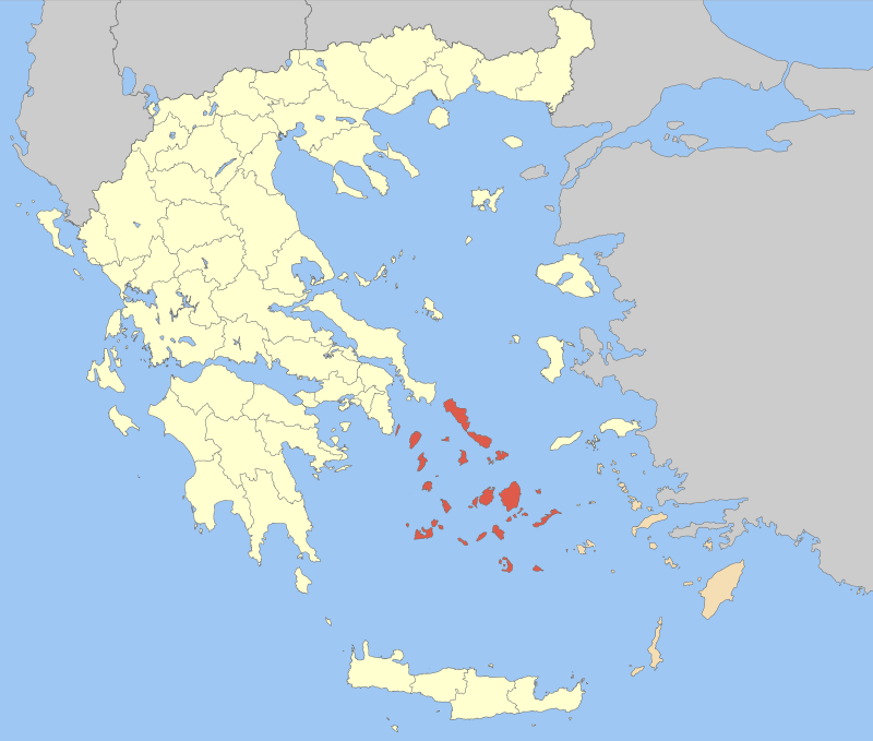
Cyclades is an island group in Europe (Mediterranean Sea), covering an estimated 26,035 km².

The Cyclades (; Greek: Κυκλάδες, romanized: Kykládes, IPA: [ciˈkla.ðes]) is an archipelago in the Aegean Sea, southeast of the Greek mainland and a former administrative prefecture of Greece. The archipelago is one of Greece's island groups which constitute the Aegean archipelago. One of the group's constituent islands Delos is significant and was sacred to Ancient Greek religion, thus the islands surrounding (κyκλόω, kyklóō cognate to cycle) it take after it (Κυκλάδες νήσοι, Kykládes nísoi, 'surrounding islands').

The largest island of the Cyclades is Naxos; the most populated, however, is Syros.

Adapted from Wikipedia: Cyclades (CC BY-SA 4.0).

Feature class
Island group
Mapped extent
26,035 km²
Size rank
#103 of 445 islands
Region
Europe
Subregion
Mediterranean Sea
Coordinates
37.0966°, 25.0081°
Summits:
Psiloritis (2,456 m), Mount Olympus (2,917 m), Musala (2,925 m)
Ranges:
Pindus Mountains (Europe), Al Jabal al Akhdar (Africa)
Settlements:
Piraeus (149 km), Athens (150 km), Hios (173 km)

View on the live map

More about Cyclades

Geography

The Cyclades includes about 220 islands, the major ones being Amorgos, Anafi, Andros, Antiparos, Delos, Ios, Kea, Kimolos, Kythnos, Milos, Mykonos, Naxos, Paros, Folegandros, Serifos, Sifnos, Sikinos, Syros, Tinos, and Thira or Santoríni. There are also many minor islands (the Lesser Cyclades) including Donousa, Eschati, Gyaros, Irakleia, Koufonisia, Makronisos, Rineia, and Schoinousa. The name "Cyclades" refers to the islands forming a circle ("circular islands") around the sacred island of Delos. Most of the smaller islands are uninhabited.

Ermoupoli on Syros is the chief town and administrative center of the former prefecture.

The islands are peaks of a submerged mountainous terrain, with the exception of two volcanic islands, Milos and Santorini.

History

The significant Late Neolithic and Early Bronze Age Cycladic culture is best known for its schematic, flat sculptures carved out of the islands' pure white marble centuries before the great Middle Bronze Age Minoan civilization arose in Crete to the south. These figures have been looted from burials to satisfy a thriving Cycladic antiquities market since the early 20th century.

A distinctive Neolithic culture amalgamating Anatolian and mainland Greek elements arose in the western Aegean before 4000 BCE, based on emmer and wild-type barley, sheep and goats, pigs, and tuna that were apparently speared from small boats (Rutter). Excavated sites include Chalandriani, Phylakopi, Skarkos, Saliagos and Kephala (on Kea) with signs of copper working.

Sections adapted from Wikipedia: Cyclades (CC BY-SA 4.0).

Cyclades: Key Facts

Key facts about Cyclades
Area2,572 km²
Surrounded byAegean Sea

Facts from Wikidata Q171132 (CC0).

Visiting Cyclades

The Cyclades are a group of Greek Islands, located in the southern part of the Aegean Sea (south of Athens and north of Crete). The archipelago contains some 2,200 islands, islets and rocks; but only 33 islands are inhabited. The Cyclades are best known for the islands of Santorini and Mykonos, but plenty of less heavily-touristed islands can be found here.

Travel notes adapted from Wikivoyage: Cyclades (CC BY-SA 4.0).

Ionian Islands
Image via Wikimedia Commons (author and licence on the file page).

Ionian Islands

Island group · 10,588 km²

Ionian Islands is an island group in Europe (Mediterranean Sea), covering an estimated 10,588 km².

The Ionian Islands (Modern Greek: Ιόνια νησιά, Ionia nisia; Ancient Greek, Katharevousa: Ἰόνιαι Νῆσοι, Ioniai Nēsoi) are a group of islands in the Ionian Sea, west of mainland Greece. They are traditionally called the Heptanese ("Seven Islands"; Ἑπτάνησα, Heptanēsa or Ἑπτάνησος, Heptanēsos; Italian: Eptaneso), but the group includes many smaller islands in addition to the seven principal ones.

As a distinct historic region, the collective of islands dates to the centuries-long Venetian rule, which kept them outside Ottoman control, and created a distinct cultural identity with many Italian influences. The Ionian Islands became part of the modern Greek state in 1864. Administratively today, they belong to the Ionian Islands Region except for Kythera, which belongs to the Attica Region.

Adapted from Wikipedia: Ionian Islands (CC BY-SA 4.0).

Feature class
Island group
Mapped extent
10,588 km²
Size rank
#151 of 445 islands
Region
Europe
Subregion
Mediterranean Sea
Coordinates
38.1410°, 20.5900°
Summits:
Mount Olympus (2,917 m), Korab (2,764 m), Daravica (2,656 m)
Ranges:
Pindus Mountains (Europe), Al Jabal al Akhdar (Africa)
Settlements:
Agrinio (89 km), Pirgos (91 km), Patra (100 km)

View on the live map

More about Ionian Islands

Geography

The six northern islands are off the west coast of Greece, in the Ionian Sea. The seventh island, Kythira, is off the southern tip of the Peloponnese, the southern part of the Greek mainland. Kythira is not part of the region of the Ionian Islands, as it is included in the region of Attica.

History

The islands were settled by Greeks at an early date, possibly as early as 1200 BC, and certainly by the 9th century BC. The early Eretrian settlement at Kerkyra was displaced by colonists from Corinth in 734 BC. The islands were mostly a backwater during Ancient Greek times and played little part in Greek politics. The one exception was the conflict between Kerkyra and its mother-city Corinth in 434 BC, which brought intervention from Athens and triggered the Peloponnesian War.

Ithaca was the name of the island home of Odysseus in the epic Ancient Greek poem the Odyssey by Homer. Attempts have been made to identify Ithaki with ancient Ithaca, but the geography of the real island cannot be made to fit Homer's description.

Demographics

The Ionian Islands' official population, excluding Kythera, in 2011 was 207,855, decreased by 1.50% compared to the population in 2001. Nevertheless, the region remains the third by population density with 90.1/km2 nationwide, well above the national of 81.96/km2. The most populous of the major islands is Corfu with a population of 104,371, followed by Zakynthos (40,759), Kefalonia (35,801), Lefkada (23,693) and Ithaca (3,231). The foreign-born population was in 2001 19,360 or 9.3%, the majority of which was concentrated in Corfu and Zakynthos. Most of them originate from Albania (13,536). The fertility rate for 2011 according to Eurostat was 1.35 live births per woman during her lifetime.

Economy

The regional gross domestic product for 2010 was 4,029 million euros. The GDP per capita for the same year was 18,440 euros per capita which was lower than the national median of 20,481. However, the GDP per capita of Kefalonia and Zante, 23,275 and 24,616 respectively, was much higher than the national figure. Additionally, unemployment for 2012 was 14.7, the lowest among all Greek regions, and much lower compared to the national unemployment of 24.2.

The region is a popular tourist destination. The airports of Corfu, Zante and Kefalonia were in the top ten in Greece by number of international arrivals, with 1,386,289 international arrivals for 2012, with Corfu being the sixth airport by number of arrivals nationwide.

Sections adapted from Wikipedia: Ionian Islands (CC BY-SA 4.0).

Ionian Islands: Key Facts

Key facts about Ionian Islands
Area2,307 km²
Population204,562 (2018)
Highest pointMount Ainos
Surrounded byIonian Sea

Facts from Wikidata Q170295 (CC0).

Visiting Ionian Islands

The Ionian Islands refers to the chain of Greek Islands stretching along the west coast of Greece in the Ionian Sea. Due to historical facts the isolated islands of Kithira and Antikythera, south of the Peloponnese, are here included in this group. These islands are traditionally called the Heptanese, i.e. "the Seven Islands" in Greek, but the group includes many smaller islands as well as the seven principal ones. The islands are well known for their beautiful sandy beaches, crystal clear waters, architecture, charming villages and stunning scenic countryside which is verdant and flourishing with greenery and nature. Each Ionian island has a distinct character. The islands are also known by their Italian names. These islands are known to be covered with green unlike the Cyclades, which is due to rareness of rain. Historically, these islands had a common fate, especially the three major islands of Corfu, Cefalonia and Zante.

Travel notes adapted from Wikivoyage: Ionian Islands (CC BY-SA 4.0).

Crete
Image via Wikimedia Commons (author and licence on the file page).

Crete

Island · 8,286 km²

Crete is an island in Europe (Mediterranean Sea), covering an estimated 8,286 km².

Crete ( KREET) is the largest and most populous island of Greece, the 89th largest island in the world, and the fifth largest island in the Mediterranean Sea, after Sicily, Sardinia, Cyprus, and Corsica. Crete is located approximately 100 km (62 mi) south of the Peloponnese, and about 300 km (190 mi) southwest of Anatolia. Crete has an area of 8,450 km2 (3,260 mi2) and a coastline of 1,046 km (650 mi). It bounds the southern border of the Aegean Sea, with the Sea of Crete (or North Cretan Sea) to the north and the Libyan Sea (or South Cretan Sea) to the south. Crete covers 260 km from west to east but is narrow from north to south, spanning three degrees of longitude but only half a degree of latitude.

Crete and its surrounding islands and islets form the Region of Crete (Greek: Περιφέρεια Κρήτης), which is the southernmost of the 13 top-level administrative units of Greece, and the fifth most populous of Greece's regions. Its capital and largest city is Heraklion, located on the island's north shore. As of 2021, the region had a population of 624,408. The Dodecanese are located to the northeast of Crete, while the Cyclades are situated to the north, separated by the Sea of Crete.

Adapted from Wikipedia: Crete (CC BY-SA 4.0).

Feature class
Island
Mapped extent
8,286 km²
Size rank
#165 of 445 islands
Region
Europe
Subregion
Mediterranean Sea
Coordinates
35.1496°, 24.9860°
Summits:
Psiloritis (2,456 m), Mount Olympus (2,917 m), Selvili Tepe (1,023 m)
Ranges:
Al Jabal al Akhdar (Africa), Pindus Mountains (Europe)
Settlements:
Iraklio (24 km), Hania (97 km), Rodos (325 km)

View on the live map

More about Crete

Physical geography and climate

Crete is the largest island in Greece and the fifth largest island in the Mediterranean Sea. It is located south of almost the rest of the country, in the southern part of the Aegean Sea separating the Aegean from the Libyan Sea.

The island has an elongated shape: it spans 260 km (160 mi) from east to west, is 60 km (37 mi) at its widest point, and narrows to as little as 12 km (7.5 mi) (close to Ierapetra). Crete covers an area of 8,336 km2 (3,219 mi2), with a coastline of 1,046 km (650 mi); to the north, it broaches the Sea of Crete (Greek: Κρητικό Πέλαγος); to the south, the Libyan Sea (Greek: Λιβυκό Πέλαγος); in the west, the Myrtoan Sea, and toward the east the Carpathian Sea. It lies approximately 160 km (99 mi) south of the Greek mainland.

History

In the later Neolithic and Bronze Age periods, under the Minoans, Crete had a highly developed, literate civilization. It has been ruled by various ancient Greek entities, the Roman Empire, the Byzantine Empire, the Emirate of Crete, the Republic of Venice and the Ottoman Empire. After a brief period of independence (1897–1913) under a provisional Cretan government, it joined the Kingdom of Greece. It was occupied by Nazi Germany during the Second World War.

Stone tools suggest that archaic humans may have visited Crete as early as 130,000 years ago, but there is no evidence of permanent settlement of the island until the Neolithic, around 7,000 BCE.

Human geography

Crete is the most populous island in Greece, with a population of over 600,000. Approximately 42% of residents live in the island's main cities and towns, while 45% reside in rural areas.

Crete with its nearby islands form the Crete Region (Greek: Περιφέρεια Κρήτης, Periféria Krítis, [periˈferia ˈkritis]), one of the 13 regions of Greece which were established in the 1987 administrative reform. Under the 2010 Kallikratis plan, the powers and authority of the regions were redefined and extended. The region is based at Heraklion and is divided into four regional units (pre-Kallikratis prefectures). From west to east these are: Chania, Rethymno, Heraklion, and Lasithi. These are further subdivided into 24 municipalities.

Tourism

Crete is one of the most popular holiday destinations in Greece. In 2023, Crete welcomed 6.3 million visitors, who stayed on average 5.4 days on the island, reflecting significant overtourism pressure on coastal infrastructure. 15% of all arrivals in Greece come through the city of Heraklion (port and airport), while charter journeys to Heraklion make up about 20% of all charter flights in Greece. The number of hotel beds on the island increased by 53% in the period between 1986 and 1991.

Sections adapted from Wikipedia: Crete (CC BY-SA 4.0).

Crete: Key Facts

Key facts about Crete
Area8,336 km²
Population623,065 (2011)
Highest pointMount Ida
Surrounded byMediterranean Sea, Sea of Crete

Facts from Wikidata Q34374 (CC0).

Visiting Crete

Crete (Greek: Κρήτη / Kríti, sometimes spelled "Krete" in English) is the largest of the Greek islands and is the fifth largest in the Mediterranean Sea - after Sicily, Sardinia, Cyprus, and Corsica. It is located between the Sea of Crete and the Libyan Sea, south of the Peloponnese. It contains the southernmost city within the European continent, Ierapetra, which is only about 645 km (401 mi) from the coast of Libya. Crete is approximately 260 km (160 mi) long and 60 km (37 mi) wide. The island is divided into four prefectures: from west to east, Chania, Rethymnon, Heraklion, and Lasithi. Crete's population is approximately 650,000.

While all Greek islands have their own charm and beauty, Crete is undoubtedly one of the most diverse, blessed with a remarkable amount of truly spectacular natural beauty and a wide variety of varied architecture that pays tribute to its ancient Minoan past and chronicles its history of conquest from the Greek mainland, the Venetian era, and the Turkish/Ottoman period.

Travel notes adapted from Wikivoyage: Crete (CC BY-SA 4.0).

Rhodes
Image via Wikimedia Commons (author and licence on the file page).

Rhodes

Island · 1,429 km²

Rhodes is an island in Europe (Mediterranean Sea), covering an estimated 1,429 km².

Rhodes ( ; Greek: Ρόδος, romanized: Ródos [ˈroðos]) is the largest of Greece's Dodecanese islands and their historical capital, as well as the ninth largest island in the Mediterranean Sea. Administratively, Rhodes constitutes a municipality within the Rhodes regional unit, which is part of the South Aegean administrative region. The principal town of the island and seat of the municipality is the city of Rhodes, home to 50,636 inhabitants according to the 2011 census. By 2022, the island's population had grown to 125,113 people. Located northeast of Crete and southeast of Athens, Rhodes is referred to by several nicknames: "the Island of the Sun" after its patron sun god Helios; "the Pearl Island"; and "the Island of the Knights", a reference to the Knights of Saint John of Jerusalem, who ruled the island from 1310 to 1522.

Historically, Rhodes was famous for the Colossus of Rhodes, one of the Seven Wonders of the Ancient World. The medieval Old Town of the City of Rhodes has been declared a World Heritage Site. During the early 21st century the island was one of the most popular tourist destinations in Europe.

Adapted from Wikipedia: Rhodes (CC BY-SA 4.0).

Feature class
Island
Mapped extent
1,429 km²
Size rank
#275 of 445 islands
Region
Europe
Subregion
Mediterranean Sea
Coordinates
36.1789°, 27.9250°
Summits:
Psiloritis (2,456 m), Selvili Tepe (1,023 m), Mount Olympus (2,917 m)
Ranges:
Taurus Mountains (Asia), Al Jabal al Akhdar (Africa)
Settlements:
Rodos (40 km), Muğla (122 km), Söke (181 km)

View on the live map

More about Rhodes

Geography

The island of Rhodes is shaped like a spearhead, 79.7 km (49.5 mi) long and 38 km (24 mi) across at its widest, with a total area of approximately 1,400 km2 (541 sq mi) -much larger than the rest of the Dodecanese put together- and a coastline of approximately 220 km (137 mi). Limestone is the main bedrock. The city of Rhodes is located at the northern tip of the island, as well as the site of the ancient and modern commercial harbours. The main airport is the Diagoras International Airport (IATA code: RHO), located 14 km (9 mi) to the southwest of the city in Paradisi. The road network radiates from the city along the east and west coasts.

History

During the Late Pleistocene, the island was inhabited by an unnamed species of dwarf elephant. The island has been inhabited by humans since at least the late Neolithic, as evidenced by remains found at Kalythies cave on the northeast of the island.

At the end of the 3rd millennium BC, during the Early Bronze Age, major urban settlements began to develop on Rhodes, such as Asomatos, which is the earliest known urban centre on the island. Duck shaped vases found at Asomatos suggest contact with Cyprus as well as elsewhere in the Aegean region during this time.

The Minoan Civilisation established a settlement at Tiranda on the northwest of the island during the 16th century BC, presumably to facilitate trade.

In the 15th century BC, Mycenaean Greeks settled.

Economy

The economy is tourist-oriented, and the most developed sector is service. Tourism has elevated Rhodes economically, compared to the rest of Greece.

Small industries process imported raw materials for local retail, though other industry includes agricultural goods production, stockbreeding, fishery and winery.

Tourism

Rhodes is one of the most popular tourist destinations in Greece. After Crete, the island is the most visited destination in Greece, with arrivals standing at 1,785,305 in 2013. In 2014 they stood at 1,931,005, while in 2015 the arrival number reduced slightly and stood at 1,901,000. The average length of stay is estimated at 8 days. Guests from Great Britain, Israel, France, Italy, Sweden and Norway constitute the biggest portion in terms of the arrivals by country. In Rhodes, the supply of available rooms is high, since more than 550 hotels are operating in the island, the majority of which are two star hotels.

Sections adapted from Wikipedia: Rhodes (CC BY-SA 4.0).

Rhodes: Key Facts

Key facts about Rhodes
Area1,400 km²
Population127,613 (2020)
Highest pointAtavyros
Surrounded byAegean Sea, Lycian Sea

Facts from Wikidata Q43048 (CC0).

Visiting Rhodes

For the Sydney suburb, see Sydney/Sydney Olympic Park

Rhodes (Greek: Ρόδος, Ródos) is one of the largest and most fertile of the Greek Islands, and is one of the most visited because of its combination of beaches, archaeological sites, and extensive medieval town. The climate is particularly good, with the weather typically sunny and mild. The island is usually counted as one of the Dodecanese, but due to its importance for travelers is considered separately here.

The rock-rose is so prolific here that it has been named the 'Island of Roses,' though modern scholars doubt the ancient theory that the island's name comes from the Greek word for rose. While the northern coast is renowned for its lively tourist resorts the south offers tranquil beaches and a slower, more simple pace of life.

Travel notes adapted from Wikivoyage: Rhodes (CC BY-SA 4.0).

Lesbos
Image via Wikimedia Commons (author and licence on the file page).

Lesbos

Island · 10 km²

Lesbos is an island in Europe (Mediterranean Sea), covering an estimated 10 km².

Lesbos or Lesvos (Greek: Λέσβος, romanized: Lésvos [ˈlezvos]) is a Greek island located in the northeastern Aegean Sea. It has an area of 1,633 km2 (631 sq mi), with approximately 400 km (249 mi) of coastline, making it the third largest island in Greece and the eighth largest in the Mediterranean. It is separated from Asia Minor by the narrow Mytilini Strait. On the southeastern coast is the island's capital and largest city, Mytilene (Μυτιλήνη), whose name is also used for the island as a whole. Lesbos is a separate regional unit with the seat in Mytilene, which is also the capital of the larger North Aegean region. The region includes the islands of Lesbos, Chios, Ikaria, Lemnos, and Samos. The total population of the island was 83,755 in 2021. A third of the island's inhabitants live in the capital, while the remainder are concentrated in small towns and villages. The largest are Plomari, Agia Paraskevi, Polichnitos, Agiassos, Eresos, Gera, and Molyvos (the ancient Mythimna).

Adapted from Wikipedia: Lesbos (CC BY-SA 4.0).

Feature class
Island
Mapped extent
10 km²
Size rank
#440 of 445 islands
Region
Europe
Subregion
Mediterranean Sea
Coordinates
39.3726°, 26.3452°
Summits:
Mount Olympus (2,917 m), Musala (2,925 m), Psiloritis (2,456 m)
Ranges:
Balkan Mountains (Europe), Pindus Mountains (Europe)
Settlements:
Mitilini (34 km), Çanakkale (86 km), Hios (113 km)

View on the live map

More about Lesbos

Geography

Lesbos lies in the far east of the Aegean sea, facing the Turkish coast (Gulf of Edremit) from the north and east; at the narrowest point, the Mytilini Strait is about 5.5 km (3.4 mi) wide. In late Palaeolithic/Mesolithic times it was joined to the Anatolian mainland before the end of the Last Glacial Period. The shape of the island is roughly triangular, but it is deeply intruded by the gulfs of Kalloni, with an entry on the southern coast, and of Gera, in the southeast.

The island is forested and mountainous with two large peaks, Mount Lepetymnos at 968 m (3,176 ft) and Mount Olympus at 967 m (3,173 ft) (not to be confused with Mount Olympus in Thessaly on the Greek mainland), dominating its northern and central sections.

History

The oldest artifacts found on the island may date to the late Paleolithic period. Important archaeological sites on the island are the Neolithic cave of Kagiani, probably a refuge for shepherds, the Neolithic settlement of Chalakies.

Lesbos has been inhabited since at least 3000 BC. There is the extensive habitation of Thermi (3000–1000 BC). The largest habitation is found in Lisvori, dating back to 2800–1900 BC, part of which is submerged in shallow coastal waters.

Lesbos (Lāzpa) is mentioned in two Hittite texts from the Late Bronze Age, a period during which the island appears to have been a dependent of the Seha River Land. The Manapa-Tarhunta letter recounts an incident in which a group of purple-dyers from Lesbos defected from the Sehan king.

Geology

The entire territory of Lesbos is "Lesvos Geopark", which is a member of the European Geoparks Network (since 2000) and Global Geoparks Network (since 2004) on account of its outstanding geological heritage, educational programs and projects, and promotion of geotourism.

This geopark was enlarged from former "Lesvos Petrified Forest Geopark". Lesbos contains one of the few known petrified forests, called the Petrified forest of Lesbos, and it has been declared a Protected Natural Monument. Fossilised plants have been found in many localities on the western parts of the island. The fossilised forest was formed during the Late Oligocene to Lower–Middle Miocene, as determined by the intense volcanic activity in the area.

Climate

The island has a hot-summer Mediterranean climate (Csa in the Köppen climate classification). The mean annual temperature is 18 °C (64 °F), and the mean annual rainfall is 750 mm (30 in). Its exceptional sunshine makes it one of the sunniest islands in the Aegean Sea. Snow and very low temperatures are rare.

Sections adapted from Wikipedia: Lesbos (CC BY-SA 4.0).

Lesbos: Key Facts

Key facts about Lesbos
Area1,641 km²
Population83,800 (2021)
Surrounded byAegean Sea

Facts from Wikidata Q128087 (CC0).

Visiting Lesbos

Lesbos (Λέσβος), or Lesvos, is the northernmost of the East Aegean Islands of Greece, projecting out of the Asia Minor mainland.

It is a birthplace of numerous poets and writers since the Greek antiquity. The island of Lesbos continues to inspire, through this cultural heritage, its natural beauty, and its easygoing lifestyle expressed by its people as a familiarity towards all its visitors.

Travel notes adapted from Wikivoyage: Lesvos (CC BY-SA 4.0).

More on Greece

Quick Answers

What is the largest island in Greece?
Cyclades, at 26,035 km². Ionian Islands is second at 10,588 km². Rankings cover the islands indexed in YearMaps.
How many islands are there in Greece?
YearMaps lists 6 islands for Greece. This is the number mapped in the atlas, not an official national count.