Skip to content
YearMaps
Chile · Lakes

Largest Lakes in Chile

Lago Buenos Aires is the largest of the 6 lakes recorded for Chile, at 1,895 km², ahead of Lago Viedma at 1,077 km². The full list follows.

How this list is built: Ranked by mapped surface area. A lake on a border is listed under each country it lies in, with the area of the whole lake. It covers the lakes indexed in YearMaps, drawn from open geospatial data, and is not an exhaustive national register.

Lakes Listed
6
Top Ranked
1,895 km²
Lago Buenos Aires
Second
1,077 km²
Lago Viedma
Profiled Below
4
Photo, encyclopedia text and figures
Largest Lakes in Chile
#NameSurface Area
1Lago Buenos Aires1,895 km²
2Lago Viedma1,077 km²
3Lago San Martín1,053 km²
4Lago Llanquihue854 km²
5Lago Ranco433 km²
6Lago Rupanco210 km²

The Lakes of Chile in Detail

The 4 lakes above that have an encyclopedia article, in the same order, each with its photograph, figures and the places around it.

Lago Buenos Aires
Image via Wikimedia Commons (author and licence on the file page).

Lago Buenos Aires

Lake · 1,895 km²

Lago Buenos Aires is a lake in Chile and Argentina, with a mapped surface area of about 1,895 km². About 58% of its surface lies in Chile, and the rest in Argentina.

General Carrera Lake (Chilean part, officially renamed in 1959) or Lake Buenos Aires (Argentine part) is a deep lake located in Patagonia and shared by Argentina and Chile. Both names are internationally accepted, while the autochthonous name of the lake is Chelenko, which means "stormy waters" in Aonikenk. Another historical name is Coluguape from Mapuche, a derivative of this name is applied to Colhué Huapí Lake after Argentine explorer Francisco Moreno reached this lake in 1876 conflating it with Coluguape (General Carrera Lake).

The lake is of glacial origin and is surrounded by the Andes mountain range. The lake drains to the Pacific Ocean on the west through the Baker River. During the last glaciation the lake drained to the Atlantic through Deseado River.

The weather in this area of Chile and Argentina is generally cold and humid. But the lake itself has a sunny microclimate, a weather pattern enjoyed by the few settlements along the lake, such as Puerto Guadal, Fachinal, Mallín Grande, Puerto Murta, Puerto Río Tranquilo, Puerto Sánchez, Puerto Ingeniero Ibáñez and Chile Chico in Chile, and Los Antiguos and Perito Moreno in Argentina.

Adapted from Wikipedia: General Carrera Lake (CC BY-SA 4.0).

Surface area
1,895 km²
Area rank
#106 of 756 indexed
Type
Lake
Countries
Chile, Argentina
Coordinates
-46.4820°, -71.5198°

Among the 756 water bodies with a mapped extent in YearMaps, Lago Buenos Aires ranks #106 by surface area, after Kremenchuk Reservoir (1,897 km²) and ahead of Nam Co (1,880 km²). Areas are computed from the mapped outline and are approximate.

Settlements on the shore:
Coihaique (116 km), Castro (472 km), Ancud (539 km)
Watercourses:
Deseado (River), Chubut (River)
Other water nearby:
Lago San Martín (1,053 km²), Lago Viedma (1,077 km²)

View on the live map

More about Lago Buenos Aires

Geology

The lake occupies a continental-scale graben formed by SWS-ENE normal faults that have resulted in down-dropping the bottom of the lake to 350 meters (1,150 ft) below mean sea level. Preservation of younger lithostratigraphic units within the graben form reverse stratigraphy with older units exposed at higher topographic elevations to the south. The graben channeled mountain glaciers which formed terminal moraine helping to modify the present-day shape of the lake. The tectonic activity that formed the depression can be inferred to subduction of the triple joint that has occurred over the past 20 million years, as indicated by ripple marks in volcaniclastic sediments observed along the southern shoreline.

Sections adapted from Wikipedia: General Carrera Lake (CC BY-SA 4.0).

Lago Buenos Aires: Key Facts

Key facts about Lago Buenos Aires
Surface area1,850 km²
Maximum depth590 m
Surface elevation202 m
OutflowsBaker River
Drainage systemBaker Basin

Facts from Wikidata Q503842 (CC0).

Lago Viedma
Image via Wikimedia Commons (author and licence on the file page).

Lago Viedma

Lake · 1,077 km²

Lago Viedma is a lake in Argentina and Chile, with a mapped surface area of about 1,077 km².

Viedma Lake (Spanish: Lago Viedma, Spanish pronunciation: [laɣo ˈβjeðma]) is a Patagonian lake in the province of Santa Cruz, Argentina, situated near its border with Chile. Measuring approximately 50 miles (80 km) in length, it is a major elongated trough lake formed from melting glacial ice. Viedma Lake is the second largest perennial lake located entirely within Argentina.

The name of the lake comes from the Spanish explorer Antonio de Viedma, who in 1783 became the first European to reach its shores.

The town of El Chaltén and the Andes peaks Cerro Torre and Fitz-Roy lie in the proximity of the lake.

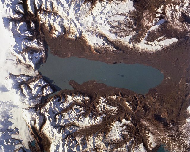
Lake Viedma is fed primarily by the Viedma Glacier at its western end. The Viedma Glacier measures 3 miles (5 kilometers) wide at its terminus at Lake Viedma. The brown landscape is a result of ice scouring, which left virtually no vegetation on the steep-walled valleys.

Water from Lake Viedma flows into Lake Argentino through the La Leona River, and eventually from there into the Atlantic Ocean through the Santa Cruz River.

Adapted from Wikipedia: Viedma Lake (CC BY-SA 4.0).

Surface area
1,077 km²
Area rank
#181 of 756 indexed
Type
Lake
Countries
Argentina, Chile
Coordinates
-49.6925°, -72.2564°

Among the 756 water bodies with a mapped extent in YearMaps, Lago Viedma ranks #181 by surface area, after Novosibirsk Reservoir (1,082 km²) and ahead of Lake Eyasi (1,077 km²). Areas are computed from the mapped outline and are approximate.

Settlements on the shore:
Puerto Natales (226 km), Punta Arenas (397 km), Coihaique (459 km)
Watercourses:
Gallegos (River), Deseado (River)
Other water nearby:
Lago San Martín (1,053 km²), Lago Buenos Aires (1,895 km²)

View on the live map

More about Lago Viedma

Lago Viedma: Key Facts

Key facts about Lago Viedma
Surface area1,088 km²
Surface elevation250 m
InflowsSanta Cruz River, Viedma Glacier, Las Vueltas river
OutflowsSanta Cruz River
Drainage systemSanta Cruz River

Facts from Wikidata Q918713 (CC0).

Lago San Martín
Image via Wikimedia Commons (author and licence on the file page).

Lago San Martín

Lake · 1,053 km²

Lago San Martín is a lake in Argentina and Chile, with a mapped surface area of about 1,053 km². About 47% of its surface lies in Chile, and the rest in Argentina.

The lake known as O'Higgins in Chile and San Martín in Argentina is located around coordinates 48°50′S 72°36′W in Patagonia, between the Aysén Region and the Santa Cruz Province.

Adapted from Wikipedia: O'Higgins/San Martín Lake (CC BY-SA 4.0).

Surface area
1,053 km²
Area rank
#189 of 756 indexed
Type
Lake
Countries
Argentina, Chile
Coordinates
-48.9305°, -72.5386°

Among the 756 water bodies with a mapped extent in YearMaps, Lago San Martín ranks #189 by surface area, after Pyhjrvi (1,054 km²) and ahead of Lac St.-Jean (1,048 km²). Areas are computed from the mapped outline and are approximate.

Settlements on the shore:
Puerto Natales (335 km), Coihaique (354 km), Punta Arenas (513 km)
Watercourses:
Gallegos (River), Deseado (River)
Other water nearby:
Lago Viedma (1,077 km²), Lago Buenos Aires (1,895 km²)

View on the live map

More about Lago San Martín

History

The lake was divided in the 1902 Arbitral award of the Andes between Argentina and Chile. Disregarding the Chilean agent Bolados and the Argentine agent Arenberg, the demarcator, British Colonel Herbert Leland Crosthwait placed border marker 62 south of Lake O'Higgins/San Martín using a pile of stones and a paper inside a bottle, as he was short on time.

Sections adapted from Wikipedia: O'Higgins/San Martín Lake (CC BY-SA 4.0).

Lago San Martín: Key Facts

Key facts about Lago San Martín
Surface area1,058 km²
Maximum depth836 m
Surface elevation285 m

Facts from Wikidata Q2005708 (CC0).

Lago Llanquihue
Image via Wikimedia Commons (author and licence on the file page).

Lago Llanquihue

Lake · 854 km²

Lago Llanquihue is a lake in Chile, with a mapped surface area of about 854 km².

Llanquihue Lake is the second-largest lake in Chile with an area of about 871 km2 (336 sq mi), after Lake General Carrera which is shared with Argentina. It is situated in the southern Los Lagos Region in the Llanquihue and Osorno provinces. The lake's fan-like form was created by successive piedmont glaciers during the Quaternary glaciations. The last glacial period is called Llanquihue glaciation in Chile after the terminal moraine systems around the lake.

Some historians consider Llanquihue Lake to have been within the range of ancient Chono nomadism.

Llanquihue Lake is located in southern Chile a territory of northern Patagonia in the Los Lagos Region. The lake's views of Volcán Osorno make the surrounding cities such as Puerto Varas tourism hotspots.

Adapted from Wikipedia: Llanquihue Lake (CC BY-SA 4.0).

Surface area
854 km²
Area rank
#220 of 756 indexed
Type
Lake
Country
Chile
Coordinates
-41.1086°, -72.8034°

Among the 756 water bodies with a mapped extent in YearMaps, Lago Llanquihue ranks #220 by surface area, after Ozero Pyasino (859 km²) and ahead of Gaoyou Hu (847 km²). Areas are computed from the mapped outline and are approximate.

Settlements on the shore:
Puerto Varas (29 km), Puerto Montt (42 km), Osorno (67 km)
Watercourses:
Limay (River), Bío-Bío (River)
Other water nearby:
Embalse Ezequiel Ramos Mexia (819 km²), Lago Musters (381 km²)

View on the live map

More about Lago Llanquihue

Lago Llanquihue: Key Facts

Key facts about Lago Llanquihue
Surface area860 km²
Maximum depth350 m
Surface elevation70 m
OutflowsMaullín River
Drainage systemMaullin basin

Facts from Wikidata Q826464 (CC0).

More on Chile

Quick Answers

What is the largest lake in Chile?
Lago Buenos Aires, at 1,895 km². Lago Viedma is second at 1,077 km². Rankings cover the lakes indexed in YearMaps.
How many lakes are there in Chile?
YearMaps lists 6 lakes for Chile. This is the number mapped in the atlas, not an official national count.