Skip to content
YearMaps
Angola · Landforms

Mountain Ranges, Deserts and Landforms of Angola

Africa is the largest of the 8 mountain ranges, deserts and other landforms recorded for Angola, at 29.41M km², ahead of Congo Basin at 3.11M km². The full list follows.

How this list is built: Ranked by mapped area. Covers mountain ranges, deserts, plateaus, named glaciers, plains, basins, peninsulas and capes. One that crosses a border is listed under every country it lies in, with the area of the whole feature. It covers the mountain ranges, deserts and other landforms indexed in YearMaps, drawn from open geospatial data, and is not an exhaustive national register.

Landforms Listed
8
Top Ranked
29.41M km²
Africa
Second
3.11M km²
Congo Basin
Profiled Below
5
Photo, encyclopedia text and figures
Mountain Ranges, Deserts and Landforms of Angola
#NameArea
1Africa29.41M km²
2Congo Basin3.11M km²
3Kalahari Desert763,095 km²
4Bié Plateau162,228 km²
5Crystal Mountains147,032 km²
6Huíla Plateau30,845 km²
7Namib Desert3,621 km²
8Kaokoland3,037 km²

The Landforms of Angola in Detail

The 5 mountain ranges, deserts and other landforms above that have an encyclopedia article, in the same order, each with its photograph, figures and the places around it.

Congo Basin
Image via Wikimedia Commons (author and licence on the file page).

Congo Basin

Basin · 3.11M km²

Congo Basin is a basin in Africa, covering an estimated 3.11M km². It extends across the DR Congo, the Central African Republic, Angola, the Republic of the Congo, Cameroon, South Sudan, Sudan, Burundi, Gabon, Malawi, Rwanda, Uganda and Zambia. It is the 11th-largest of the 231 landforms with a mapped extent in YearMaps.

The Congo Basin is the sedimentary basin of the Congo River. The Congo Basin is located in Central Africa, in a region known as west equatorial Africa. The region is sometimes known simply as the Congo. It contains some of the largest tropical rainforests in the world and is an important source of water used in agriculture and energy generation.

The rainforest in the Congo Basin is the largest rainforest in Africa and second only to the Amazon rainforest in size, with 300 million hectares compared to the 800 million hectares in the Amazon. Because of its size and diversity the basin's forest is important for mitigating climate change in its role as a carbon sink. However, deforestation and degradation of the ecology by the impacts of climate change may increase stress on the forest ecosystem, in turn making the hydrology of the basin more variable. A 2012 study finds that the variability in precipitation caused by climate change will negatively affect economic activity in the basin.

Eight sites of the Congo Basin are inscribed on the World Heritage List, five being also on the list of World Heritage in Danger (all five located in Democratic Republic of the Congo).

Adapted from Wikipedia: Congo Basin (CC BY-SA 4.0).

Feature class
Basin
Mapped extent
3.11M km²
Size rank
#11 of 231 landforms
Region
Africa
Countries
DR Congo, Central African Republic, Angola, Republic of the Congo, Cameroon, South Sudan, Sudan, Burundi, Gabon, Malawi, Rwanda, Uganda, Zambia
Coordinates
-0.6351°, 21.4534°
Ranges:
Ruwenzori Range (Africa), Inyanga Mountains (Africa)
Settlements:
Capenda-Camulemba (75 km), Saurimo (208 km), Lucapa (228 km)

View on the live map

More about Congo Basin

Geology

The Congo Basin is a large depression within the Congo Craton, making it a patch of relatively recent (Phanerozoic-aged, and mostly Mesozoic and onwards) sedimentary rock within a large, otherwise ancient (Archean-aged) piece of exposed continental crust. The deformation of the craton began as early as the late Cambrian or early Ordovician and continued over the Paleozoic, but the deformation over this period led to rapid erosion of much of the Paleozoic rock, creating a large unconformity. Sediment started to rapidly accumulate in the basin from the Mesozoic (Triassic) up to the present day.

Deposits throughout the Jurassic suggest the presence of a freshwater, lacustrine habitat in the basin, and this continued into the Early Cretaceous.

Climate

The Congo Basin is a globally important climatic region with annual rainfall of between 1,500 to 2,000 millimetres (59 to 79 in). It is one of three hotspots of deep convection (thunderstorms) in the tropics, the other two being over the Maritime continent and the Amazon. These three regions together drive the climate circulation of the tropics and beyond. The Congo Basin has the highest lightning strike frequency of anywhere on the planet. The high rainfall supports the second-largest rainforest on Earth, which is a globally significant carbon sink and an important component of the global carbon cycle.

Averaged across the basin, there are two major rainfall seasons in March to May and September to November.

Ecology and protection

At a global level, Congo's forests act as the planet's second lung, counterpart to the rapidly dwindling Amazon. They are a huge "carbon sink", trapping carbon that could otherwise remain carbon dioxide. The Congo Basin holds roughly 8% of the world's forest-based carbon. Despite this importance, it gets far less scientific attention than the Amazon or the tropical forests of South East Asia. If these woodlands are deforested, the carbon they trap will be released into the atmosphere. Predictions for future unabated deforestation estimate that by 2050 activities in the DRC will release roughly the same amount of carbon dioxide as the United Kingdom has emitted over the last 60 years. A 2013 study by British scientists shows that deforestation in the Congo Basin rainforest is slowing.

History

The first inhabitants of the Congo Basin area were believed to be pygmies, and at that time, the dense forests and wet climate kept the population of the region low, with the prevention of hunter-gatherer society, whose remnants of their culture survive to the present day. Eventually Bantu peoples migrated there and founded the Kingdom of Kongo.Belgium, France, and Portugal later established colonial control over the entire region by the late 19th century.

Sections adapted from Wikipedia: Congo Basin (CC BY-SA 4.0).

Congo Basin: Key Facts

Key facts about Congo Basin
Area1,000,000 km²
Highest pointMount Karisimbi
OnRiver Congo

Facts from Wikidata Q932289 (CC0).

Kalahari Desert
Image via Wikimedia Commons (author and licence on the file page).

Kalahari Desert

Desert · 763,095 km²

Kalahari Desert is a desert in Africa, covering an estimated 763,095 km². It extends across Namibia, Botswana, South Africa and Angola. It is the 3rd-largest of the 58 deserts with a mapped extent in YearMaps.

The Kalahari Desert is a large semiarid sandy savanna in Southern Africa covering 900,000 km2 (350,000 sq mi), including much of Botswana, as well as parts of Namibia and South Africa.

Adapted from Wikipedia: Kalahari Desert (CC BY-SA 4.0).

Feature class
Desert
Mapped extent
763,095 km²
Size rank
#3 of 58 deserts
Region
Africa
Countries
Namibia, Botswana, South Africa, Angola
Coordinates
-25.0256°, 22.1471°
Ranges:
Witwatersrand (Africa), Inyanga Mountains (Africa)
Settlements:
Lubango (233 km), Namibe (324 km), Tômbua (329 km)

View on the live map

More about Kalahari Desert

Geography

Drainage of the desert is by dry black valleys, seasonally inundated pans, and the large salt pans of the Makgadikgadi Pan in Botswana and Etosha Pan in Namibia. The only permanent river, the Okavango, flows into a delta in the northwest, forming marshes that are rich in wildlife. Ancient dry riverbeds—called Ouramba—traverse the central northern reaches of the Kalahari and provide standing pools of water during the rainy season.

A semi-desert, with huge tracts of excellent grazing after good rains, the Kalahari supports more animals and plants than a true desert, such as the Namib Desert to the west. There is little rainfall, and the summer temperature is very high.

Climate

The climate is sub-humid rather than semi-arid in the north and east, where the dry forests, savannahs, and salt lakes prevail. South and west, where the vegetation is predominantly xeric savanna or even a semi-desert, the climate is "Kalaharian" semi-arid. The Kalaharian climate is subtropical: average annual temperature greater than or equal to 18 °C (64 °F), at peaks reaching 40 °C (104 °F) and above, with mean monthly temperature of the coldest month strictly below 18 °C (64 °F), and is semi-arid with the dry season from April to September, the coldest six months of the year. It is the southern tropical equivalent of the Sahelian climate with the wet season during summer.

History

The Kalahari Desert was not always an arid environment. Geological and paleoclimatic evidence suggests that during parts of the late Pleistocene, the region experienced significantly wetter and cooler conditions. Fossil flora and fauna from Gcwihaba Cave in northwestern Botswana indicate that the area supported more abundant vegetation and permanent water sources between roughly 30,000 and 11,000 Before Present (BP), with the most humid period occurring after 17,500 BP. Sediment cores, pollen records, and fossilized animal remains from other parts of the Kalahari, including the Makgadikgadi Pans and Okavango Basin, corroborate these findings, showing evidence of large paleolakes and river systems that once covered much of what is now desert.

Sections adapted from Wikipedia: Kalahari Desert (CC BY-SA 4.0).

Kalahari Desert: Key Facts

Key facts about Kalahari Desert
Area930,000 km²
Highest pointBrandberg

Facts from Wikidata Q47700 (CC0).

Bié Plateau
Image via Wikimedia Commons (author and licence on the file page).

Bié Plateau

Plateau · 162,228 km²

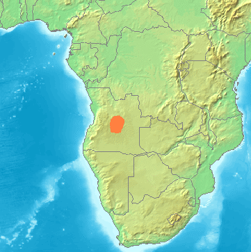
Bié Plateau is a plateau in Africa, covering an estimated 162,228 km².

The Bié Plateau or Central Plateau of Angola is a plateau that occupies most of central Angola. The elevation of the plateau is from 1,520 m (4,990 ft) to 1,830 m (6,000 ft).

Five major rivers have their headwaters or significant tributaries on the plateau: the Cunene, Cuanza, Okavango, Zambezi, and Congo rivers. It has relatively fertile soil and high rainfall, compared to the coastal region of Angola to its west. Its climate is cool and has enough rainfall to allow for the cultivation of coffee, corn, rice, sisal, sugarcane, and peanuts. Along the more elevated parts, more rain falls, but it gradually declines further within. About half of the rural population of Angola reside on the Bié plateau. The Benguela Railway connects it to the ocean and its principal towns are Huambo and Kuito.

Historically, the plateau was deeply affected by slavery, with estimates of as much as half the local population being enslaved in the mid-1800s.

Adapted from Wikipedia: Bié Plateau (CC BY-SA 4.0).

Feature class
Plateau
Mapped extent
162,228 km²
Size rank
#26 of 69 plateaus
Region
Africa
Coordinates
-13.3310°, 19.1518°
Summits:
Monalanong Hill (1,494 m), Inyangani (2,592 m), Mont Mohi (3,480 m)
Ranges:
Inyanga Mountains (Africa), Witwatersrand (Africa)
Settlements:
Luena (190 km), Kuito (262 km), Mavinga (303 km)

View on the live map

More about Bié Plateau

Bié Plateau: Key Facts

Key facts about Bié Plateau
Highest pointMount Moco

Facts from Wikidata Q776345 (CC0).

Huíla Plateau
Image via Wikimedia Commons (author and licence on the file page).

Huíla Plateau

Plateau · 30,845 km²

Huíla Plateau is a plateau in Africa, covering an estimated 30,845 km².

The Huíla Plateau (Portuguese: Planalto da Huíla) is a large plateau and highlands region in south-central Angola. It is part of the Great Escarpment and forms the southernmost stretch of the Central Plateau of Angola. It is separated from the Atlantic Coast by the Serra da Leba and Serra da Chela mountain ranges, extending southward to the Namib Desert at Angola's border with Namibia. Its western edge forms the border between the Huíla and Namibe Provinces.

Adapted from Wikipedia: Huíla Plateau (CC BY-SA 4.0).

Feature class
Plateau
Mapped extent
30,845 km²
Size rank
#54 of 69 plateaus
Region
Africa
Coordinates
-15.4781°, 15.0723°
Summits:
Monalanong Hill (1,494 m), Mont Bengoué (1,070 m), Inyangani (2,592 m)
Ranges:
Witwatersrand (Africa), Inyanga Mountains (Africa)
Settlements:
Lubango (181 km), Ongwediva (267 km), Huambo (312 km)

View on the live map

More about Huíla Plateau

Geography

The Huíla Plateau is located in south-central Angola, on the southern extremity of the Bié Plateau. Its southern edge skirts the Namib Desert, and its southeastern edge runs along the Cunene Basin.

Its western edge forms the natural boundary between the Huíla and Namibe Provinces, roughly extending from Chongorói, Benguela Province, in the north, to Onkokwa, Cunene Province, in the south. This edge is characterized by deep escarpments, such as the Tundavala Gap, and is part of the Great Escarpment. Along this edge are the Serra da Leba and Serra de Chela mountain ranges. Beyond this is a desert/beach region along the Atlantic Coast.

The plateau is subdivided into two main plateaus: the Humpata and the Bimbe Plateaus. Lubango, the capital of Huíla Province, sits atop Humpata Plateau.

Geology

The Huíla Plateau sits atop a layer of dolomitic bedrock called the Leba-Tchamalindi Formation, which formed during the Paleoproterozoic. The plateau was once on the shoreline, supported by the presence of reef knolls inside its limestone outcroppings. Over time, heavy erosion and tectonic activity created a karstic landscape. Today, this presents as a vast network of steep ridges, valleys, and cliffs, and subterranean caves, sinkholes, and tunnels.

Climate

The climate of the Huíla Plateau is highly variable. The monsoon lasts from October to April, followed by a dry season during the off months, with an average annual precipitation from 800 to 900 mm (31 to 35 in). Temperatures typically average 17–18°C, with extreme highs of 35–37°C in summer and extreme lows of –2°C in winter. Inside the Tchivinguiro Depression, a valley in the Humpata Plateau, exists a Mediterranean microclimate, which receives markedly more rainfall: approximately 926 mm (36.5 in) per year.

Sections adapted from Wikipedia: Huíla Plateau (CC BY-SA 4.0).

Kaokoland
Image via Wikimedia Commons (author and licence on the file page).

Kaokoland

Geoarea · 3,037 km²

Kaokoland is a geoarea in Africa, covering an estimated 3,037 km². It extends across Angola and Namibia.

Kaokoland was an administrative unit and a Bantustan in northern South West Africa (now Namibia). Established in 1980 during the apartheid era, it was intended to be a self-governing homeland of the Ovahimba, but an actual government was never established, and the territory was administered by the leaders of Hereroland. Like other homelands in South West Africa, the Kaokoland Bantustan was abolished in May 1989, at the beginning of the transition of Namibia towards independence.

"Kaokoland" remains as an informal name for the geographic area, while the political unit of administration since 1990 has been Kunene Region. The area is in the Kaokoveld ecoregion. The area is one of the wildest and least populated areas in Namibia, with a population density of one person every 2 km2 (1/4 of the national average). The most represented ethnic group is the Himba people, who account for about 5,000 of the overall 16,000 inhabitants of Kaokoland. The main settlement in Kaokoland was the city of Opuwo.

Adapted from Wikipedia: Kaokoland (CC BY-SA 4.0).

Feature class
Geoarea
Mapped extent
3,037 km²
Size rank
#146 of 231 landforms
Region
Africa
Countries
Angola, Namibia
Coordinates
-13.4181°, 13.0531°
Ranges:
Witwatersrand (Africa), Inyanga Mountains (Africa)
Settlements:
Lubango (109 km), Namibe (137 km), Benguela (185 km)

View on the live map

More about Kaokoland

Geography

The Kaokoland area extends south-north from the Hoanib river to the Kunene river (that also marks the border between Namibia and Angola). It is largely mountainous, with the northern Baynes Mountains reaching their maximum elevation at 2039 m. Other notable mountain ranges of Kaokoland include the Otjihipa Mountains (to the north) and the Hartmann Mountains (to the east). The land is generally dry and rocky, especially to the south, where it borders on the Namib Desert; nevertheless, it has several rivers as well as falls. The most notable falls in Kaokoland are the Ruacana Falls (120 m high, 700 m wide) and the Epupa Falls, both formed by the Kunene river. The northern part of Kaokoland is greener, with vegetation thriving valleys such as the Marienfluss and Hartmann Valley.

History

Before colonialism, Kaokoland was mostly inhabited by the Ovambo, Nama, and Herero people. In the second half of the 19th century, a group of Herero crossed the Kunene River, migrating north to what is now Angola, joining with the Bushmen in Southern Angola; the modern day Himba people originated from this Angolan Herero group. In 1884, Kaokoland became part of German South West Africa, and the Namibian Herero people changed much of their habits and costumes as a consequence of German rule. After World War I, South Africa received the mandate from the League of Nations to administer the territory of Namibia, which became, for all practical purposes, a province of South Africa.

Tourism and transportation

After the end of the bush war, Kaokoland has become a common tourist destination in Namibia, due to its proximity to the Etosha National Park (to the south), the unspoiled nature (with several spots suitable for activities such as rafting and trekking), and the opportunity to visit traditional Himba villages. Notable landmarks in the area include the Epupa Falls, Sesfontein, Himba villages, and the Ondurusa Rapids.

Kaokoland is one of the wildest regions of Southern Africa, with very few roads and structures. The only road that is accessible to non-4WD vehicles is the one connecting Sesfontein and Opuwo. Many roads in Kaokoland are often in very bad condition and may even be challenging for 4WDs, especially during the rainy season.

Sections adapted from Wikipedia: Kaokoland (CC BY-SA 4.0).

More on Angola

Quick Answers

What is the largest landform in Angola?
Africa, at 29.41M km². Congo Basin is second at 3.11M km². Rankings cover the mountain ranges, deserts and other landforms indexed in YearMaps.
How many mountain ranges, deserts and other landforms are there in Angola?
YearMaps lists 8 mountain ranges, deserts and other landforms for Angola. This is the number mapped in the atlas, not an official national count.