
Ports & Harbours of the Irish Sea and the western coasts of Britain and Ireland
YearMaps maps 101 harbours on the Irish Sea and the western coasts of Britain and Ireland, in 4 countries and territories. The largest by the World Port Index's harbour size are Manchester, Foynes, Belfast, Rade de Brest, Barry and Bristol. 11 are written up in full below, and every harbour is listed with its depths, tidal range and the largest ships it takes.
Between Great Britain and Ireland lie the Irish Sea and St George's Channel, which open south to the Celtic Sea and the Bristol Channel, with one of the largest tidal ranges in the world, and north to the sea lochs and islands of western Scotland. Liverpool rose on the Mersey with the Atlantic trade, Cardiff and Swansea shipped Welsh coal, and Glasgow built ships on the Clyde. The Atlantic harbours of Ireland are covered here as well.
- Harbours
- 101
- Countries
- 4
- Large Harbours
- 4
- Written Up
- 11
Map of the Ports of the Irish Sea and the western coasts of Britain and Ireland
Blue dots are the harbours of the World Port Index; tap or click one to open its entry. Use the layer panel to add trade routes, rivers and historical borders.
Harbours of the Irish Sea and the western coasts of Britain and Ireland in Detail
The 11 harbours of the Irish Sea and the western coasts of Britain and Ireland with an encyclopedia article, each with its figures from the World Port Index.

Foynes
Major harbour · Ireland
Shannon Foynes Port (Irish: Calafort na Sionainne agus Fhainge) is a port operating company managing the operations of cargo facilities within the Shannon Estuary. It is the second largest port in Ireland. It is operated and managed by the Shannon Foynes Port Company (SFPC), whose main operating office is based in Foynes, County Limerick. SFPC has statutory jurisdiction over all marine activities in the estuary between a line drawn from Kerry Head to Loop Head, and Limerick.
Adapted from Wikipedia: Shannon Foynes Port (CC BY-SA 4.0).
- Harbour size
- Major
- Channel depth
- 45.7 m
- Anchorage depth
- 5.5 m
- Cargo pier depth
- 5.5 m
- Oil terminal depth
- 27.4 m
- Tidal range
- 5 m
- Largest vessel
- large vessels
- Country
- Ireland
- Province
- Ireland
- Coordinates
- 52.6200°, -9.1200°

Barry
Medium harbour · United Kingdom
Barry Docks (Welsh: Dociau'r Barri) is a port facility in the town of Barry, Vale of Glamorgan, Wales, a few miles southwest of Cardiff on the north shore of the Bristol Channel. The docks were opened in 1889 by David Davies and John Cory as an alternative to the congested and expensive Cardiff Docks to ship coal carried by rail from the South Wales Coalfield. The principal engineer was John Wolfe Barry, assisted by Thomas Forster Brown and Henry Marc Brunel, son of the engineer Isambard Kingdom Brunel.
The docks occupy the former sound between Barry Island and the mainland. The contractors built dams to connect each end of the island to the mainland, drained or pumped the water from the site and excavated it. They used the material to level the area around the docks and for the core of breakwaters to protect the entrance. The works included a basin with gates at each end, which served as a lock between the sea entrance and the docks, the dock walls and quays, coal loading equipment and railways to deliver coal from the mines to the docks. A second dock and second entrance lock were added in 1898. The Barry Dock Offices were built in 1897–1900 by Arthur E.
Adapted from Wikipedia: Barry Docks (CC BY-SA 4.0).
- Harbour size
- Medium
- Channel depth
- 56.7 m
- Anchorage depth
- 38.4 m
- Cargo pier depth
- 42.1 m
- Oil terminal depth
- 42.1 m
- Tidal range
- 10 m
- Largest vessel
- medium vessels
- Country
- United Kingdom
- Province
- Wales
- Coordinates
- 51.4000°, -3.2700°
More about Barry
History
There was a coal boom between 1890 and 1914, and the dockyard business was immediately successful. By the end of 1889 Barry had exported 1.073 million long tons (1,090,000 t). In 1890 the docks shipped 3.192 million long tons (3,243,000 t). In 1891 the Barry Dock and Railway Company was renamed the Barry Railway Company. The chairman was Lord Windsor, who owned much of the land. David Davies was deputy chairman and responsible for running the company. 3,000 ships used the dock in 1899, taking 7 million long tons (7,100,000 t) of coal. In 1903 the docks shipped 9 million long tons (9,100,000 t). Only 10% of the coal went to other ports in Britain and Ireland. Most went overseas for use in steam engines.
Facilities
The dock entrance is on the east side of Barry Island, which protects it from winds from the west and southwest. Two rubble breakwaters with six-ton stone blocks on the seaward side protect the entrance from winds from other directions. Given the height of the tides, the breakwaters are substantial structures, 46 feet (14 m) high at the deepest part, and 200 feet (61 m) wide at the base. There is a 350 feet (110 m) gap between the breakwaters, from which a dredged channel of 1,455 feet (443 m) leads to the dock basin entrance. The channel has a least depth of 2.5 metres (8 ft 2 in), with a depth of 14 metres (46 ft) at spring tides and 12 metres (39 ft) at neap tides. At high-water spring tides the depth of water at the entrance to the basin is 38 feet (12 m).
Background
For most of the 19th century Cardiff was the main port for exporting South Wales coal. Cardiff shipped 998,000 long tons (1,014,000 t; 1,118,000 short tons) of coal in 1859, 1.9 million long tons (1,900,000 t; 2,100,000 short tons) in 1867 and 7.7 million long tons (7,800,000 t; 8,600,000 short tons) of coal in 1889. John Crichton-Stuart, 2nd Marquess of Bute (1793–1848) had built the Cardiff Docks, which remained in the possession of his son. Other coal mine owners had no choice but to use these docks and the Taff Vale Railway to export their product under terms dictated by Bute. They complained about delays and congestion at the port, and said that Bute was charging extortionate fees.
Location
Barry is situated on the north shore of the Bristol Channel, a few miles southwest of Cardiff.
Before the docks were created, Barry Sound lay between Barry Island and the mainland, sheltered from storms by the island and by Friar's Point. It had been a port since medieval times. The island was about 1 mile (2 km) long and 1⁄2 mile (800 m) wide, with a height of 120 feet (37 m) above mean sea level. The mainland slopes up to the north, so the sound was well sheltered from the wind. No rivers or streams ran into the sound.
The Bristol Channel is known for its tidal range.
Sections adapted from Wikipedia: Barry Docks (CC BY-SA 4.0).

Holyhead
Small harbour · United Kingdom
The Port of Holyhead (Welsh: Porthladd Caergybi) is a commercial and ferry port in Anglesey, United Kingdom, handling more than 2 million passengers each year. It covers an area of 240 hectares, and is operated by Stena Line Ports Ltd. The port is the principal link for crossings from north Wales and central and northern England to Ireland. The port is partly on Holy Island and partly on Salt Island (Welsh: Ynys Halen). It is made up of the Inner Harbour, the Outer Harbour and the New Harbour (opened in 1880), all sheltered by the Holyhead Breakwater which, at 2.7 kilometres, is the longest in the UK.
Adapted from Wikipedia: Port of Holyhead (CC BY-SA 4.0).
- Harbour size
- Small
- Channel depth
- 53 m
- Anchorage depth
- 34.7 m
- Cargo pier depth
- 31.1 m
- Tidal range
- 5 m
- Largest vessel
- medium vessels
- Country
- United Kingdom
- Province
- Wales
- Coordinates
- 53.3200°, -4.6300°
More about Holyhead
History
Formerly subservient to Beaumaris as the region's main port, Holyhead came into its own in the early 19th century, when Thomas Telford built a new road to connect north Wales with London. The Admiralty Pier was constructed in 1821, and was used by the City of Dublin Steam Packet Company. The so-called "Irish Mail Line" of the Chester and Holyhead Railway ran from Holyhead railway station to the pier. The Admiralty Arch was built in 1824, marking the end of Telford's new road. The arch was designed by Thomas Harrison and its main purpose was to commemorate the visit of King George IV of the United Kingdom in 1821, when he arrived in Holyhead on the royal yacht, before leaving on a state visit to Ireland on the steam packet Lightning.
Sections adapted from Wikipedia: Port of Holyhead (CC BY-SA 4.0).

Ardrossan
Small harbour · United Kingdom
Ardrossan Harbour railway station is one of three remaining railway stations in the town of Ardrossan, North Ayrshire, Scotland. The station is managed by ScotRail. It is on the Ayrshire Coast Line, 32.5 miles (52.3 km) south west of Glasgow Central. The station is an interchange for Caledonian MacBrayne ferry sailings to Brodick on the Isle of Arran.
Adapted from Wikipedia: Ardrossan Harbour railway station (CC BY-SA 4.0).
- Harbour size
- Small
- Channel depth
- 49.4 m
- Anchorage depth
- 9.1 m
- Cargo pier depth
- 49.4 m
- Tidal range
- 3 m
- Largest vessel
- medium vessels
- Country
- United Kingdom
- Coordinates
- 55.6500°, -4.8200°
More about Ardrossan
History
The station was originally opened on 19 January 1987 to replace the closed Ardrossan Winton Pier railway station. Ardrossan Harbour station is slightly further inland (approximately 220 yards/200 metres to the east) than its predecessor and is sited at the end of a 1-mile (1.6 km) long branch line from Ardrossan South Beach.
Opened under sectorisation of British Rail, the station was served by ScotRail until the privatisation of British Rail.
The station is unstaffed and consists of a single platform and shelter, a short walk from the "CalMac" terminal building.
Sections adapted from Wikipedia: Ardrossan Harbour railway station (CC BY-SA 4.0).
Ardrossan: Key Facts
| Established | 1987 |
|---|---|
| Operator | ScotRail Trains (2022-) |
| On | Firth of Clyde |
Facts from Wikidata Q2420789 (CC0).

Rosslare
Small harbour · Ireland
The village of Rosslare Harbour (Irish: Calafort Ros Láir), also known as Ballygeary, grew up to serve the needs of the harbour of the same name (now called Rosslare Europort), first developed in 1906 by the Great Western Railway and the Great Southern and Western Railway to accommodate steamferry traffic between Great Britain and Ireland. This port also serves France and Spain, traffic is mainly roll-on roll-off (RoRo). Rosslare Harbour railway station opened on 30 August 1906.
Adapted from Wikipedia: Rosslare Harbour (CC BY-SA 4.0).
- Harbour size
- Small
- Channel depth
- 45.7 m
- Anchorage depth
- 45.7 m
- Cargo pier depth
- 45.7 m
- Tidal range
- 2 m
- Largest vessel
- medium vessels
- Country
- Ireland
- Province
- County Wexford
- Coordinates
- 52.2500°, -6.3300°

Port Talbot
Small harbour · United Kingdom
Port Talbot (, UK also ) is an industrial port town and community in the county borough of Neath Port Talbot, Wales, situated on the east side of Swansea Bay, approximately 8 miles (13 km) from Swansea. The Port Talbot Steelworks covers a large area of land which dominates the south east of the town. It is the largest steelworks in the United Kingdom, and one of the largest in the world, but has been under threat of closure since the 1980s. The population was 31,550 in 2021, comprising about a fifth of the 141,931 population of Neath Port Talbot.
Adapted from Wikipedia: Port Talbot (CC BY-SA 4.0).
- Harbour size
- Small
- Channel depth
- 34.7 m
- Anchorage depth
- 9.1 m
- Cargo pier depth
- 27.4 m
- Tidal range
- 6 m
- Largest vessel
- medium vessels
- Country
- United Kingdom
- Province
- Wales
- Coordinates
- 51.5800°, -3.8200°
More about Port Talbot
History
Modern Port Talbot is a town formed from the merging of multiple villages, including Baglan, Margam, and Aberafan. The name 'Port Talbot' first appears in 1837 as the name of the new docks built on the south-east side of the river Afan by the Talbot family. Over time it came to be applied to the whole of the emerging conurbation.
The earliest evidence of humans in the Port Talbot area has been found on the side of Mynydd Margam where Bronze Age farming ditches can be found from 4,000 BC. There were Iron Age hill forts on Mynydd Dinas, Mynydd Margam, Mynydd Emroch and other nearby hills. Mynydd Hawdref contains remains of an ancient Iron Age village. The Margam deer herd dates from Norman times but deer in the area were mentioned during Roman occupation.
Physical geography
Port Talbot occupies an area of low lying coastal plain between Swansea Bay to the west (within the Bristol Channel) and the hills and valleys of Margam Moors (which are part of the wider South Wales valleys) to the south. The town is built along the eastern rim of Swansea Bay in a narrow strip of coastal plain surrounding the River Afan estuary. Swansea is visible on the opposite side of the bay. The local beach is known as Aberafan Sands and is situated along the edge of the bay between the River Afan and the River Neath. The other beach in Port Talbot is Margam Sands, popularly known as Morfa Beach. The north-western edge of the town is marked by the River Neath. A landmark in the town is the Port Talbot Steelworks.
Economy
On 20 November 2007, the Department for Business, Enterprise and Regulatory Reform (BERR) granted consent for the world's largest biomass power station to be built at Port Talbot. The energy plant is capable of generating 40 MW of electricity and commenced energy production in 2019 using Grade-C waste wood sourced from local authorities, civic amenity sites and commercial or industrial sources across South Wales and the South West of England.
Potential future development currently centres around the peripheral distributor road to the south (the dual carriageway road in the Margam and Taibach areas was finished in 2013), Baglan Industrial Park and Baglan Energy Park to the west, Port Talbot Docks to the southwest, Margam Country Park to the east and the Afan Valley to the north.
Human geography
With heavy industry and an urban motorway, Port Talbot was reported as having the worst air pollution in Wales in 2005 with a PM10 particulate level of 30 μg/m3 (micrograms per cubic metre). By 2018 the air quality had improved to meet the WHO's recommended limit of 10 μg/m3.
According to the Office for National Statistics the Neath Port Talbot population had increased by 1.8 percent, from around 139,800 in 2011 to 142,300 in 2021.
Sections adapted from Wikipedia: Port Talbot (CC BY-SA 4.0).
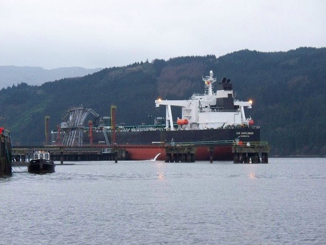
Finnart Oil Terminal
Small harbour · United Kingdom
Finnart Oil Terminal, also known as Finnart Ocean Terminal or Chap Point, is an oil depot on the eastern shore of Loch Long, Firth of Clyde on the west coast of Scotland, about 2 miles (3.2 km) north of Garelochhead on the A814 road to Arrochar. It has piers extending a short distance into the loch, providing a deep water berth for oil tankers up to 324,000 tonnes. Two pipelines connect the terminal across Scotland to the Grangemouth Refinery on the Firth of Forth on the east coast, and extensive oil storage tanks have been built into the hillside on both sides of the main road.
Adapted from Wikipedia: Finnart Oil Terminal (CC BY-SA 4.0).
- Harbour size
- Small
- Channel depth
- 5.5 m
- Anchorage depth
- 5.5 m
- Oil terminal depth
- 5.5 m
- Tidal range
- 3 m
- Largest vessel
- large vessels
- Country
- United Kingdom
- Province
- Argyll and Bute
- Coordinates
- 56.1200°, -4.8300°
More about Finnart Oil Terminal
History
The road from Gare Loch rises over high ground before descending steeply to Loch Long, and at the foot of the hill the last owner of the croft on the site built a stone into the roadside wall with the inscription "This road was made from the Castle Rosneath to Tenne Clauch in the year 1777 by his Grace John Duke of Argyll. Erected by John Fraser". The stone can still be seen in the wall, opposite the main jetty of the terminal.
The terminal takes its name from Finnart House, a country house to the east of the A814, constructed about 1832 for the Glasgow shipbuilder John Macgregor. It was designed by William Burn, who also designed Arddarroch House on the other side of the road, built in 1838 for the Glasgow merchant John McVicar. Both estates are now occupied by the oil depot.
Sections adapted from Wikipedia: Finnart Oil Terminal (CC BY-SA 4.0).
Lancaster
Small harbour · United Kingdom
The Port of Lancaster was located at the lowest crossing point on the River Lune and constitutes the central element of maritime Lancaster in north-west England. It dates back to Roman times, but is now based at Glasson Dock.
Adapted from Wikipedia: Port of Lancaster (CC BY-SA 4.0).
- Harbour size
- Small
- Anchorage depth
- 42.1 m
- Cargo pier depth
- 53 m
- Tidal range
- 3 m
- Largest vessel
- medium vessels
- Country
- United Kingdom
- Coordinates
- 54.0500°, -2.7800°
More about Lancaster
History
The port dates back to Roman times: Lancaster Roman Fort was established around 80 A.D. and the local legend of a Roman harbour is supported by the suggestion that the garrison would have been supplied more efficiently by ship than by road. However evidence of a port here is scant for both the Roman period and the subsequent Viking settlement in Lancaster.
When Lancaster received its charter as a borough in 1193, this recognised the development of the town. It was in 1297 that Lancaster was recorded as a port along with Cartmel and Workington and Ravenglass.
Sections adapted from Wikipedia: Port of Lancaster (CC BY-SA 4.0).

Bridgwater
Very Small harbour · United Kingdom
The Port of Bridgwater is a port, originally located in the town of Bridgwater, Somerset, England. Created under the Bridgwater Navigation and Quays Act 1845 (8 & 9 Vict. c. lxxxix) it extends from Brean Down to Hinkley Point in Bridgwater Bay, and parts of the rivers Parrett (to Bridgwater), River Brue and River Axe. Although no ships now dock in the town, in 2001 103,613 (metric) tonnes of cargo were handled within the area of the port authority (compared to more than 200,000 tons (approximately equivalent to metric tonnes) in 1878), most of which were stone products through the wharf at Dunball.
Adapted from Wikipedia: Port of Bridgwater (CC BY-SA 4.0).
- Harbour size
- Very Small
- Channel depth
- 56.7 m
- Anchorage depth
- 45.7 m
- Cargo pier depth
- 38.4 m
- Tidal range
- 9 m
- Largest vessel
- medium vessels
- Country
- United Kingdom
- Coordinates
- 51.1300°, -3.0000°
More about Bridgwater
History
Old Norse bryggja (quay), though this idea has been opposed on etymological grounds.
In the Domesday Book the town is listed as Brugie, but after the Norman invasion the land was given to Walter of Douai. Hence, as well as Burgh-Walter, an alternative version is that it derives from "Bridge of Walter" (i.e. Walter's Bridge).
What can be gained from the etymology of the town's name, is that Bridgwater has been a port of trade since pre-1200AD, when the first stone bridge was built within the town, which also marked the highest point of safe navigation for seagoing vessels. The town was the lowest practical crossing point on the River Parrett, although an alternate crossing via large stones at Combwich also existed but only at low tide.
Sections adapted from Wikipedia: Port of Bridgwater (CC BY-SA 4.0).

Port Ellen
Very Small harbour · United Kingdom
Port Ellen (Scottish Gaelic: Port Ilein) is a small town on the island of Islay, in Argyll, Scotland. The town is named after the wife of its founder, Walter Frederick Campbell. Its previous name, Leòdamas, is derived from Old Norse meaning "Leòd's Harbour".
Port Ellen is built around Loch Leòdamais, Islay's main deep water harbour. It is the largest town on Islay, only slightly larger than Bowmore and provides the main ferry connection between Islay and the mainland, at Kennacraig. The Port Ellen Distillery was first established in the 1820s and ceased production of Scotch whisky in 1983, until reopening in 2024. The large malting continues to produce for the majority of the distilleries on Islay.
Adapted from Wikipedia: Port Ellen (CC BY-SA 4.0).
- Harbour size
- Very Small
- Channel depth
- 53 m
- Anchorage depth
- 34.7 m
- Cargo pier depth
- 53 m
- Tidal range
- 1 m
- Largest vessel
- medium vessels
- Country
- United Kingdom
- Coordinates
- 55.6300°, -6.2000°
More about Port Ellen
History
The area around Port Ellen has a variety of archaeological sites covering the Neolithic, Bronze and Iron Age periods. There are standing stones at Kilbride, a fort at Borraichill Mor, several chambered cairns, and a chapel at Cill Tobar Lasrach. Nearby lie the ruined remains of the 14th-century Dunyvaig Castle, once a fortress of the MacDonald Lords of the Isles.
The current town was planned by Walter Frederick Campbell and founded in 1821 originally intended to support the herring industry. It was originally called Port Ellinor in honour of his wife, Lady Eleanor Charteris (d. 1832), daughter of Francis Douglas, 8th Earl of Wemyss.
Sections adapted from Wikipedia: Port Ellen (CC BY-SA 4.0).

Heysham
Very Small harbour · United Kingdom
Heysham Port is situated by the village of Heysham, Lancashire, England. The harbour ships mainly roll-on/roll-off freight, with one passenger service run by the Isle of Man Steam Packet Company, which operates a twice daily sailing to Isle of Man. There are three freight routes run by CLdN RoRo and Stena Line which all sail to Ireland daily. Heysham Port railway station links it to Lancaster via Morecambe. Adjacent to the dock site is Heysham nuclear power station.
Adapted from Wikipedia: Heysham Port (CC BY-SA 4.0).
- Harbour size
- Very Small
- Channel depth
- 34.7 m
- Anchorage depth
- 34.7 m
- Cargo pier depth
- 49.4 m
- Oil terminal depth
- 53 m
- Tidal range
- 9 m
- Largest vessel
- medium vessels
- Country
- United Kingdom
- Coordinates
- 54.0300°, -2.9200°
More about Heysham
History
In 1891, the Midland Railway, which already operated Morecambe Harbour four miles to the north-east, gave notice of its intention to develop a new harbour at Heysham and appointed consulting engineers James Abernethy and his son to undertake a feasibility study of the project. The plan was for an enclosed dock accessed through a lock, but idea made no further progress.
In 1895, a much larger Heysham port plan was put forward by Messrs James Abernethy & Son, in conjunction with the Midland Railway's chief engineer. This formed the basis of the harbour which was built, although there were many changes as work progressed and the full scheme was never completed.
Sections adapted from Wikipedia: Heysham Port (CC BY-SA 4.0).
All Harbours of the Irish Sea and the western coasts of Britain and Ireland
101 harbours, the largest first by the index's harbour size. Channel depth and tidal range set the physical limit on which ships can call. 16 of them are recorded in the source with the city they serve.
| Harbour | Country | Size | Channel | Anchorage | Tide | Largest vessel | Map |
|---|---|---|---|---|---|---|---|
| Manchester | United Kingdom | Major | 49.4 m | — | 3 m | medium vessels | |
| Foynes | Ireland | Major | 45.7 m | 5.5 m | 5 m | large vessels | |
| Belfast | United Kingdom | Major | 42.1 m | — | 2 m | large vessels | |
| Rade de Brestserves Brest | France | Major | 31.1 m | — | 7 m | medium vessels | |
| Barry | United Kingdom | Medium | 56.7 m | 38.4 m | 10 m | medium vessels | |
| Bristol | United Kingdom | Medium | 45.7 m | — | 9 m | medium vessels | |
| Barrow In Furness | United Kingdom | Medium | 38.4 m | 38.4 m | 6 m | medium vessels | |
| Dublin | Ireland | Medium | 38.4 m | — | 4 m | large vessels | |
| Greenock | United Kingdom | Medium | 38.4 m | — | 3 m | large vessels | |
| Milford Haven | United Kingdom | Medium | 38.4 m | 38.4 m | 4 m | large vessels | |
| Newport | United Kingdom | Medium | 38.4 m | 20.1 m | 29 m | large vessels | |
| Cobh | Ireland | Medium | 34.7 m | 20.1 m | 3 m | medium vessels | |
| Bideford | United Kingdom | Small | 56.7 m | 31.1 m | 5 m | medium vessels | |
| Fleetwood | United Kingdom | Small | 56.7 m | 5.5 m | 8 m | medium vessels | |
| Limerick | Ireland | Small | 56.7 m | — | 5 m | medium vessels | |
| Millport | United Kingdom | Small | 56.7 m | 34.7 m | 8 m | — | |
| Sharpness | United Kingdom | Small | 56.7 m | 45.7 m | 5 m | large vessels | |
| Coleraine | United Kingdom | Small | 53 m | 34.7 m | 2 m | medium vessels | |
| Holyhead | United Kingdom | Small | 53 m | 34.7 m | 5 m | medium vessels | |
| Swansea | United Kingdom | Small | 53 m | — | 6 m | large vessels | |
| Ardrossan | United Kingdom | Small | 49.4 m | 9.1 m | 3 m | medium vessels | |
| Campbeltown | United Kingdom | Small | 49.4 m | 38.4 m | 3 m | medium vessels | |
| New Ross | Ireland | Small | 49.4 m | 49.4 m | 4 m | medium vessels | |
| Silloth | United Kingdom | Small | 49.4 m | 45.7 m | 4 m | medium vessels | |
| Avonmouth | United Kingdom | Small | 45.7 m | 38.4 m | 9 m | medium vessels | |
| Douglas | Isle of Man | Small | 45.7 m | — | 15 m | medium vessels | |
| Ramsey | Isle of Man | Small | 45.7 m | 49.4 m | 4 m | — | |
| Rosslare | Ireland | Small | 45.7 m | 45.7 m | 2 m | medium vessels | |
| Larne | United Kingdom | Small | 42.1 m | 34.7 m | 2 m | large vessels | |
| Port Talbot | United Kingdom | Small | 34.7 m | 9.1 m | 6 m | medium vessels | |
| St. Mary'S (Scilly Isl.) | United Kingdom | Small | 34.7 m | 49.4 m | 5 m | medium vessels | |
| Fishguard | United Kingdom | Small | 31.1 m | 27.4 m | 4 m | large vessels | |
| Oban | United Kingdom | Small | 31.1 m | 34.7 m | 3 m | — | |
| Finnart Oil Terminal | United Kingdom | Small | 5.5 m | 5.5 m | 3 m | large vessels | |
| Scrabster Harbor | United Kingdom | Small | 5.5 m | 12.8 m | 4 m | large vessels | |
| Caernarvon | United Kingdom | Small | — | 49.4 m | 5 m | — | |
| Kilroot | United Kingdom | Small | — | 38.4 m | — | medium vessels | |
| Lancaster | United Kingdom | Small | — | 42.1 m | 3 m | medium vessels | |
| Bird Port | United Kingdom | Very Small | 56.7 m | 49.4 m | 6 m | medium vessels | |
| Bridgwater | United Kingdom | Very Small | 56.7 m | 45.7 m | 9 m | medium vessels | |
| Crinan (Canal) | United Kingdom | Very Small | 56.7 m | 53 m | 3 m | medium vessels | |
| Hayle | United Kingdom | Very Small | 56.7 m | 31.1 m | 15 m | medium vessels | |
| Kilkeel | United Kingdom | Very Small | 56.7 m | 34.7 m | 4 m | medium vessels | |
| Padstow | United Kingdom | Very Small | 56.7 m | 27.4 m | 6 m | medium vessels | |
| Sligo | Ireland | Very Small | 56.7 m | — | 2 m | medium vessels | |
| Watchet Harbor | United Kingdom | Very Small | 56.7 m | 45.7 m | 7 m | medium vessels | |
| Westport | Ireland | Very Small | 56.7 m | 42.1 m | 4 m | — | |
| Workington | United Kingdom | Very Small | 56.7 m | 23.8 m | 7 m | medium vessels | |
| Ayr | United Kingdom | Very Small | 53 m | — | 2 m | medium vessels | |
| Galway | Ireland | Very Small | 53 m | — | 4 m | medium vessels | |
| Neath | United Kingdom | Very Small | 53 m | 16.5 m | 6 m | — | |
| Port Ellen | United Kingdom | Very Small | 53 m | 34.7 m | 1 m | medium vessels | |
| Troon | United Kingdom | Very Small | 53 m | 49.4 m | 3 m | medium vessels | |
| Ardglass | United Kingdom | Very Small | 49.4 m | 34.7 m | 4 m | medium vessels | |
| Bangor | United Kingdom | Very Small | 49.4 m | 42.1 m | 3 m | medium vessels | |
| Drogheda | Ireland | Very Small | 49.4 m | — | 5 m | medium vessels | |
| Fenit | Ireland | Very Small | 49.4 m | 49.4 m | 4 m | medium vessels | |
| Greenore | Ireland | Very Small | 49.4 m | 23.8 m | 4 m | large vessels | |
| Kilrush | Ireland | Very Small | 49.4 m | 42.1 m | 5 m | medium vessels | |
| Kyle of Lochalsh | United Kingdom | Very Small | 49.4 m | 31.1 m | 5 m | medium vessels | |
| Mallaig | United Kingdom | Very Small | 49.4 m | 49.4 m | 4 m | medium vessels | |
| Plockton | United Kingdom | Very Small | 49.4 m | 53 m | — | medium vessels | |
| Stranraer | United Kingdom | Very Small | 49.4 m | 49.4 m | 3 m | medium vessels | |
| Valentia | Ireland | Very Small | 49.4 m | 56.7 m | 3 m | medium vessels | |
| Warren Point | United Kingdom | Very Small | 49.4 m | 45.7 m | 3 m | medium vessels | |
| Waterford | Ireland | Very Small | 49.4 m | — | 4 m | large vessels | |
| Ardrishaig | United Kingdom | Very Small | 45.7 m | 45.7 m | 2 m | medium vessels | |
| Bowling | United Kingdom | Very Small | 45.7 m | — | 3 m | medium vessels | |
| Castle Bay | United Kingdom | Very Small | 45.7 m | 42.1 m | 3 m | — | |
| Old Kilpatrick | United Kingdom | Very Small | 45.7 m | — | 3 m | — | |
| Portree Harbor | United Kingdom | Very Small | 45.7 m | 5.5 m | 4 m | medium vessels | |
| Renfrewserves Glasgow | United Kingdom | Very Small | 45.7 m | — | 3 m | medium vessels | |
| Rothesay Dock | United Kingdom | Very Small | 45.7 m | — | 3 m | — | |
| Stornoway Harbor | United Kingdom | Very Small | 45.7 m | 27.4 m | 4 m | medium vessels | |
| Ullapool | United Kingdom | Very Small | 45.7 m | 5.5 m | 4 m | medium vessels | |
| Castletown Bearhaven | Ireland | Very Small | 42.1 m | 42.1 m | 4 m | medium vessels | |
| Lochboisdale | United Kingdom | Very Small | 42.1 m | 12.8 m | 3 m | medium vessels | |
| Aultbea | United Kingdom | Very Small | 38.4 m | 31.1 m | 11 m | — | |
| Bantry | Ireland | Very Small | 38.4 m | 9.1 m | 4 m | large vessels | |
| Kyleakin | United Kingdom | Very Small | 38.4 m | 34.7 m | 3 m | — | |
| Rathmullan | Ireland | Very Small | 38.4 m | 20.1 m | 4 m | — | |
| Tarbert | United Kingdom | Very Small | 38.4 m | 20.1 m | 2 m | medium vessels | |
| Fort William | United Kingdom | Very Small | 34.7 m | — | 4 m | medium vessels | |
| Heysham | United Kingdom | Very Small | 34.7 m | 34.7 m | 9 m | medium vessels | |
| Mostyn | United Kingdom | Very Small | 34.7 m | 23.8 m | 5 m | medium vessels | |
| Broadford Bay | United Kingdom | Very Small | 31.1 m | 38.4 m | 13 m | — | |
| Craignure | United Kingdom | Very Small | 31.1 m | 42.1 m | — | — | |
| Lochmaddy | United Kingdom | Very Small | 31.1 m | 31.1 m | 2 m | medium vessels | |
| Ornsay | United Kingdom | Very Small | 31.1 m | 27.4 m | — | medium vessels | |
| Rothesay Harbor | United Kingdom | Very Small | 31.1 m | 27.4 m | 3 m | — | |
| Uig | United Kingdom | Very Small | 31.1 m | 42.1 m | 12 m | — | |
| Largs | United Kingdom | Very Small | 27.4 m | 38.4 m | 3 m | medium vessels | |
| Tarbert | Ireland | Very Small | 16.5 m | 34.7 m | 5 m | large vessels | |
| Glensanda | United Kingdom | Very Small | 12.8 m | 5.5 m | 4 m | large vessels | |
| Tobermory | United Kingdom | Very Small | 12.8 m | 5.5 m | 4 m | medium vessels | |
| Hunterston | United Kingdom | Very Small | 5.5 m | 9.1 m | 3 m | large vessels | |
| Killybegs | Ireland | Very Small | 5.5 m | 5.5 m | 3 m | large vessels | |
| Lamlash Harbor | United Kingdom | Very Small | 5.5 m | 5.5 m | 8 m | large vessels | |
| Gairloch | United Kingdom | Very Small | — | 5.5 m | — | medium vessels | |
| Liverpool Bay Terminal | United Kingdom | Very Small | — | — | 8 m | medium vessels | |
| Lochaline | United Kingdom | Very Small | — | 27.4 m | 5 m | medium vessels |
Port Cities of the Irish Sea and the western coasts of Britain and Ireland
The most populous cities with a harbour of the Irish Sea and the western coasts of Britain and Ireland within 25 km. Each city is listed with its country's other cities on the country page.
- Manchester2.23 million
United Kingdom · Manchester
- Glasgow1.16 million
United Kingdom · Bowling (15 km), Old Kilpatrick (14 km), Renfrew, Rothesay Dock (10 km)
- Dublin1.06 million
Capital of Ireland · Dublin
- Cardiff861,400
United Kingdom · Barry (12 km), Newport (18 km), Bird Port (19 km)
- Bristol553,528
- Belfast450,406
- Swansea294,339
United Kingdom · Swansea, Port Talbot (11 km), Neath (8 km)
- Blackpool272,792
- Cork188,907
Ireland · Cobh (14 km)
- Brest144,899
France · Rade de Brest
- Bath93,238
United Kingdom · Bristol (18 km)
- Limerick90,054
Ireland · Limerick
- Londonderry83,652
United Kingdom · Rathmullan (17 km)
- Galway75,594
Ireland · Galway
- Greenock74,635
United Kingdom · Greenock, Millport (23 km), Finnart Oil Terminal (21 km), Bowling (17 km)
- Ayr69,042
- Waterford49,275
- Dundalk38,884
Ireland · Greenore (19 km), Warren Point (16 km)
- Drogheda36,533
Ireland · Drogheda
- Douglas35,854
- Dumfries31,044
United Kingdom · Silloth (24 km)
- Tralee26,384
Ireland · Fenit (10 km)
- Penzance20,812
United Kingdom · Hayle (11 km)
- Sligo20,228
Ireland · Sligo
Countries with Harbours on the Irish Sea and the western coasts of Britain and Ireland
More Seas and Coasts
- Ports of North Sea
- Ports of Skagerrak & Kattegat
- Ports of Baltic Sea
- Ports of Norwegian Sea & European Arctic
- Ports of English Channel
- Ports of Bay of Biscay & Atlantic Iberia
See every sea, grouped from North America to Oceania & Antarctica, on the world ports index, or the voyages that crossed these waters on the famous sea voyages map.
Irish Sea & Celtic Sea: Quick Answers
- How many ports are there on the Irish Sea and the western coasts of Britain and Ireland?
- YearMaps lists 101 ports and harbours on the Irish Sea and the western coasts of Britain and Ireland, from the World Port Index of the US National Geospatial-Intelligence Agency. Small fishing harbours and private terminals outside the index are not counted.
- Which countries have ports on the Irish Sea and the western coasts of Britain and Ireland?
- United Kingdom (78), Ireland (20), Isle of Man (2) and France (1).
- What are the largest ports on the Irish Sea and the western coasts of Britain and Ireland?
- By the World Port Index's harbour size, the largest are Manchester, Foynes, Belfast, Rade de Brest, Barry and Bristol.
- What are the main port cities on the Irish Sea and the western coasts of Britain and Ireland?
- The most populous cities with a harbour here are Manchester (2.23 million), Glasgow (1.16 million), Dublin (1.06 million), Cardiff (861,400) and Bristol (553,528).