
Brythons: Map & History
The Britons, also known as Celtic Britons or ancient Britons, were the Celtic people who inhabited Great Britain from at least the British Iron Age until the High Middle Ages, at which point they diverged into the Welsh, Cornish, and Bretons.
Wikipedia Encyclopedic Compendium
Historiographical synthesis & structured realm registry
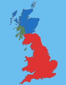
The Britons, also known as Celtic Britons or ancient Britons, were the Celtic people who inhabited Great Britain from at least the British Iron Age until the High Middle Ages, at which point they diverged into the Welsh, Cornish, and Bretons. They spoke Common Brittonic, the ancestor of the modern Brittonic languages.
Modern Countries Once Part of Brythons
At its mapped extent, Brythons covered territory in 2 present-day countries. The period shown is when the mapped borders include that country, and the note says how much of it.
States and Provinces
Largest Present-Day Cities in Its Territory
Each opens on the live map inside Brythons's borders of that time.
Derived by testing mapped cities against this polity's dated territorial polygons, so the list is indicative and follows the borders in the source dataset.
Brythons in Depth
History
There are competing hypotheses for when Celtic peoples, and the Celtic languages, first arrived in Britain, none of which have gained consensus. The traditional view during most of the twentieth century was that Celtic culture grew out of the central European Hallstatt culture, from which the Celts and their languages reached Britain in the first millennium BC. More recently, John Koch and Barry Cunliffe have challenged that with their 'Celtic from the West' theory, which has the Celtic languages developing as a maritime lingua franca or language of trade in the Atlantic Bronze Age cultural zone, which included Britain, before it spread eastward.
Culture
The Britons spoke an Insular Celtic language known as Common Brittonic. Brittonic was spoken throughout the island of Britain (in modern terms, England, Wales, and Scotland) and the Isle of Man. According to early medieval historical tradition, such as The Dream of Macsen Wledig, the post-Roman Celtic speakers of Armorica were colonists from Britain, resulting in the Breton language, a language related to Welsh and identical to Cornish in the early period, which is still used today. Thus, the area today is called Brittany (Br. Breizh, Fr. Bretagne, derived from Britannia).
Common Brittonic developed from the Insular branch of the Proto-Celtic language that developed in the British Isles after arriving from the continent at some point between the 10th and the 7th century BC.
Sections adapted from Wikipedia: Celtic Britons (CC BY-SA 4.0).
Brythons Map Over Time
Dated world maps on which Brythons appears, with the other states of the time.
Brythons Timeline
Key historical inflections from foundation to peak territorial expansion
Expansion to peak recorded area of 207,600 km² in 440 CE.
Brythons: Frequently Asked Questions
When did Brythons exist?
Brythons is dated to 439 CE – 1235 CE, in the Classical Antiquity era.
How large was Brythons at its peak?
At its peak in 440 AD Brythons covered about 207,600 km².
How did the map of Brythons change over time?
Brythons appears on 7 dated world maps in the atlas, from 500 CE to 1200 CE. Each shows its borders in that year next to the other states of the time.