
Cenozoic Era · Paleogene Period
Earth 66 Million Years Ago: The Asteroid That Ended the Dinosaurs
Earth 66 million years ago on a 3D globe: where the continents were when the Chicxulub asteroid hit, and an animation of the impact, tsunami and impact winter.
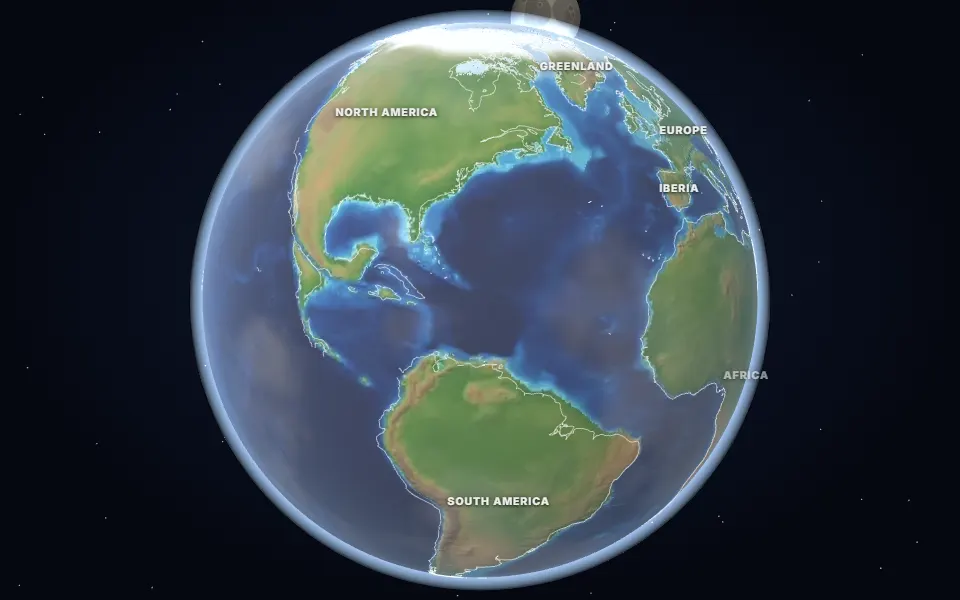 Spin it in 3D and move through time
Map: Ancient maps: PALEOMAP PaleoDEMs (Scotese & Wright 2018), CC BY 4.0 · Natural Earth.
66 million years ago, at the end of the Cretaceous period, the continents were close to their modern shapes but not their modern places. The Atlantic Ocean was much narrower, India was an island in the middle of its northward dash towards Asia, and sea levels were high enough to flood large parts of Europe and Africa.
Then an asteroid about 10 km across struck a shallow sea at the edge of what is now Mexico’s Yucatán Peninsula. It hit at around 20 km a second, from the north-east at a steep angle, and dug the Chicxulub crater, about 180 km wide.
The impact threw molten rock around the planet, set off a tsunami that crossed the oceans, lit wildfires and filled the sky with soot and sulfate. Sunlight dimmed for years and temperatures plunged in an “impact winter”. At the same time, the Deccan Traps volcanoes in India were erupting.
About three-quarters of all species died out, including every dinosaur except the birds, the ammonites and the giant marine reptiles. Mammals survived and, in the Paleogene, rapidly spread into the empty niches.
Events of the time
Deccan Traps eruptions
66.2 million years ago · Western India
Lava flows over a million km² thick erupted in India around the time of the impact, adding to the climate shock.
Chicxulub asteroid impact
66 million years ago · Yucatán Peninsula, Mexico
A ~10 km asteroid hit at ~20 km/s, making a 180 km crater, a global tsunami and an impact winter. About 75% of species, including the non-bird dinosaurs, died out.
▶ Watch it happen on the globe
Which land was under the sea 66 million years ago?
On the map nearest this age (65 million years ago, KT Boundary), about 17% of today’s land was under the sea at some point, some 25.1 million km². That makes it number 58 of the 80 maps from 535 to 5 million years ago, which run from 2% to 50%. Each map shows the greatest flooding of its stage, so no single moment had quite this much sea.
- Tethys Ocean
Permian to Miocene · Southern Europe, North Africa, the Middle East, Iran, the Himalaya and South-East Asia
The ocean between the northern and southern continents. As Africa, Arabia and India moved north it closed, raising the Alps and the Himalaya; the Mediterranean is what is left of it.
- Turgai Strait
Jurassic to Oligocene, on and off · Western Siberia and Kazakhstan, east of the Urals
A sea east of the Ural Mountains that linked the Arctic to the Tethys and kept Europe apart from Asia for animals that could not swim. The map under-draws it.
- Trans-Saharan Seaway
Late Cretaceous to Eocene · Niger, Mali, Nigeria and Algeria
A shallow sea that crossed the Sahara from the Gulf of Guinea to the Tethys. Rocks it laid down in Mali hold fossils of giant sea snakes and large catfish. The map under-draws it.
- Mississippi Embayment
Late Cretaceous to Eocene · The lower Mississippi valley, from the Gulf of Mexico north to southern Illinois
A long bay of the Gulf of Mexico that reached up the Mississippi valley. It left the sands and clays under Mississippi, Arkansas and Tennessee.
Was it under the sea? 15 of 42 cities
| Place today | 65 million years ago |
|---|---|
| Baku, Azerbaijan | Shallow sea |
| Berlin, Germany | Shallow sea |
| Bismarck, United States | Shallow sea |
| Budapest, Hungary | Shallow sea |
| Cairo, Egypt | Shallow sea |
| Dallas, United States | Shallow sea |
| London, United Kingdom | Shallow sea |
| Montgomery, Alabama, United States | Shallow sea |
| New York, United States | Shallow sea |
| Paris, France | Shallow sea |
| Perth, Australia | Shallow sea |
| Rome, Italy | Shallow sea |
| Tehran, Iran | Shallow sea |
| Vienna, Austria | Shallow sea |
| Warsaw, Poland | Shallow sea |
| Alice Springs, Australia | Land |
| Almaty, Kazakhstan | Land |
| Bangkok, Thailand | Land |
| Beijing, China | Land |
| Calgary, Canada | Land |
| Casper, Wyoming, United States | Land |
| Chicago, United States | Land |
| Delhi, India | Land |
| Denver, United States | Land |
| Hannover, Germany | Land |
| Hays, Kansas, United States | Land |
| Johannesburg, South Africa | Land |
| Kansas City, United States | Land |
| Kathmandu, Nepal | Land |
| Madrid, Spain | Land |
| Mexico City, Mexico | Land |
| Moscow, Russia | Land |
| Nairobi, Kenya | Land |
| Niamey, Niger | Land |
| Novosibirsk, Russia | Land |
| Regina, Canada | Land |
| Richmond, Queensland, Australia | Land |
| Riyadh, Saudi Arabia | Land |
| Salt Lake City, United States | Land |
| São Paulo, Brazil | Land |
| Timbuktu, Mali | Land |
| Winnipeg, Canada | Land |
1,442 marine fossil sites in the Paleobiology Database are dated closely enough to this map. Of those on today’s land, 90% fall in its shaded sea.
Seas: Ancient seas: PaleoCoastlines v7 (Kocsis & Scotese 2021), CC BY 4.0 · Fossils: Paleobiology Database.
Part of the Cenozoic Era & The Quaternary Ice Ages.